While visiting with my brother on Long Beach, NY, I did some riding on some bike trails there. I declined the invitation to do some mountain bike riding with him and his brother-in-law because my bike is a hybrid, not suited to true off-road riding. And besides, I'm much more suited to a long distance, low impact ride.
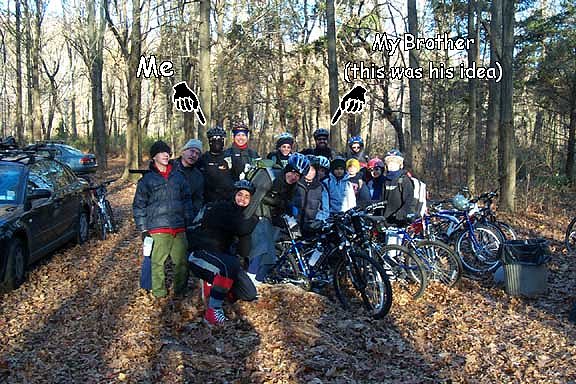
So he invited me to join him and his Boy Scout troop for a 50-mile ride along the Delaware Canal. I would drive 5 hours across the state, camp one night, ride 50 miles and then drive back that same day. Sure. Why not?
Saturday, 8 November 2003
But first, I had some geocaching to do. The ride on the PA Turnpike has a few mico-caches located at rest stops along the way. SBUX 6 - I-76 Sideling Hill and I-76 Plain (Not Fancy) Field were nothing special. More something to break up the long drive.
My route took me off of Rt. 78 in New Jersey right near the Hoffman cache. I didn't have the cache description, I wasn't in any way familiar with the area and this area was just outside the map I had uploaded to my GPSr so I pulled off of Rt. 625 at the nearest point at could find. There was a sign there that said this area was a deer population control area, making it open to limited hunting from September through February and saying that I sould wear blaze orange. I didn't have anything like that but I figgured a geek on a bicycle wouldn't look anything like a dear so long as I left my fur cuat and antler hat in the car.
It was a relatively short ride down the path and a turn onto the asphault. The coordinates led me to some grass just off the path but still 20 feet from the nearest tree. I searched in an expanding spiral at the bases of trees, behind logs and all the places I thought a cache could go. Like a spirograph drawing I would then loop back to the coordinates to see if my GPSr told me something different. I re-calibrated the electronic compass, compared it to my lensatic compass, let the unit sit for 10 minutes to get a good solid average and it still pointed to a spot where one could not possibly hide a cache. I figured that the coordinates were off and left.
On returning to civilization I read the description that it was an off-set cache, 25 yards to the East, near a discarded Pepsi can and marked with a stick stuck in the ground. My though is why didn't he just set some new coordinates?
I continued on my way, arriving in Uhlerstown several hours before I was supposed to meet the troop at the Tinicum Park. Instead of pulling into the park, I continued on to find Gecko 001.
Not being familiar with the area and foolishly not having this cache description either, I ended up pulling into the Tohickon Valley County Park. I looked at the heavily damaged park map and figured that this wasn't the right park. But I looked at the terrain and the map on my GPSr and thought that there should be a trail that wraps around. I walked a way but eventually got lazy and decided it would probably be faster to drive around to the other side.
So, I looked at the map loaded on my GPSr and went out and around until I got to a promising sign 'Stover Park Rd.' This looked like it would take me to the right place except that there were other signs like 'Bridge Closed', 'No Outlet' and 'No Turnaround'. I considered driving down there anyway and taking my chances because I was so close but I turned back and began another loop.
Hmmmm. Dark Hollow Rd. looked like it would have taken me where I wanted to go, except there were 'Road Closed' signs there, too. Another big loop finally brings me to the park, right to the 'closed' bridge which was still open to pedestrians. It would have been easy to walk across and save myself miles of driving. On top of that, the park map here clearly shows a trail following the creek around from Tohickon Valley County Park so, if I'd kept going the first time I would have had a long walk but I would have gotten here. And it probably would have taken as long to do it.
Geocaching Lesson Number Seven: Trust your instincts.
I headed off down the trail. But, as I approached a large rock formation that looked like a prime cache-hiding area, my GPS was pointing 300 feet away on the other side of the creek. I stood there for a while checking my signal. I had plenty of satellite locks and the EPE looked reasonable. The map on the GPSr seemed to indicate the cache was on this side but the vector-drwan map is not always accurate. There was a rock wall on the far side so maybe the cache was hidden there instead of the 'obvious' place amongst the rocks. I turned around and went back, crossed the bridge and headed downstream again.
What the. . . ? When I got to the aforementioned rock wall my GPSr was pointing across the creek back at the big rock fomation.
Geocaching Lesson Number Eight: No, really. Trust your instincts.
I went back over to the rocks and began my search in earnest. I was getting a solid signal and it was keeping me to a 30ft area but I couldn't turn up anything. There was a 20ft 'cave' that I looked in, even though I didn't think it would be in there (too attractive to non-cachers). Eventually 3:00 rolled around, the time I was supposed to meet my brother at the Tinicum County Park so I packed up and left in defeat.
At the park, my Brother some of the scouts had arrived. I set up my little tent and still had some time before dinner so I decided to get one more cache. Covered Bridge Tour of Bucks County - NORTH is a multi-cache that has you visiting a number of covered bridges in the area, grabbing some information from each one and using that information to calculate the cache's final coordinated. I didn't have the time to go to the Frankenfield or Erwinna bridges. But where we were camping in the park was a little over a mile from the Uhlerstown Bridge and the final stage.
So, I cheated. The final stage is one of four coordinates. They were all pretty close together so I decided to just pick one and search there. I was spot on with the first try.
Back at camp, there was plenty of spaghetti and meatbals and repeated requests for the scouts to stop playing in the fire. Was I like that when I was a scout?
I crawled into my bed early. It was going to be a cold night with temperatures as low as 20 degrees.
Sunday, 9 November 2003
I woke up very early, about 5am, I think. My body was no longer generating enough heat to keep me warm inside my sleeping bag and a layer of frost had formed on the inside of the tent. It'd had been a long time since I had been that cold. I got up and dressed so that I could move around and get warm. It was a chore getting the scouts up and going.
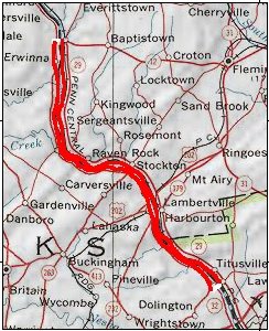
It was still pretty cold when we got on the trail. The plan was to ride South from Tinicum Park to Washington's Crossing, cross the Delaware and come back North on the New Jersy side. Once on the trail, things warmed up quickly. It was going to be a bright, sunny day and that helped, but the physical activity was going to much better than huddling inside a sleeping bag.
By the time I got down to New Hope, I had warmed up considerably. I had stripped down to my bike shorts, long sleve shirt and windbreaker. I don't know what the temperature was but it was still pretty cold. I was leading the troop and decided to take advantage of my lead to look for a virtual cache. New Hope 1 should have been easy to find but, again, I didn't have the cache description to know what I was looking for. The kids started riding past, wondering what I was doing up on the bridge and whether they should leave the trail so I abandoned my search to keep them on the right track.
I've ridden the C&O Canal Towpath in Maryland (180 miles from Cumberland to D.C.) several times and this towpath is in much better condition. I'm sure the continuous flow of water through the canal helps to limit the mosquito population, unlike the stagnant C&O which is a 180 mile mosquito nursery. I would like the opportunity to return and ride more of the rail when I don't have to be sheparding a bunch of scouts.
A similar situation occurred further down at the Washington Crossing Monument. Here are the graves a score of Washinton's troops who died of exposure during that cold winter of 1776. I took a few minutes to look for the Eric and Mary's Adventure II hidden nearby but, as we were getting close to our turn to cross the river, I didn't want the scouts to get too far ahead of me.
We crossed the bridge and waited for my brother and the others to catch up. We obeyed the signs on the bridge and walked our bikes across. Those that followed did not and were chided by a bridge guard. After that, we had lunch in the park on the New Jersy side.
The Pennsylvania side of the Delaware Canal is a very 'suburban' trail. There are many houses adjoining the canal and some are almost right on the water. And, as I rode, I saw that most homes had a canoe in the back yard. Two out of three homes, maybe more. I thought, of course! That's why they bought homes along the canal.
Yet the situation on the Delaware & Raritan Canal on the New Jersy side is different. Certainly there are fewer homes along the canal but those I did see did not have any watercraft. I did not see one canoe. The State stocks the canal with trout, the water level is even higher than on the Pennsylvania side. Why don't the New Jersians boat on their canal? Is there really a difference between Pennsylvanians and New Jersians?
When I got up to the bridge at Frenchtown and again waited for the back of the pack to catch up I saw that there was a guard booth on the New Jersy side of the bridge. I remembered back at Washington's Crossing there was also a booth there. What does New Jersy need with bridge guards? Are they expecting an invasion from Pennsylvania?
And suddenly it struck me. Yes. They are expecting an invasion. During the Revolution, George Washington led his army across the Delaware River in boats to attack Trenton. Today, New Jersians look across the river and see all those homes with canoes in their back yards and fear the Pennsylvanians from the vast, barbaric wilderness of the Appalachians paddling across in all their ravening multitudes.
OK, so maybe not.
Once we all gathered together, we crossed the bridge at Frenchtown and rode the last coupe of miles back to Tinicum Park. I had already packed so I didn't stay much beyond that to say my goodbyes and start the trek for home. I stopped to get something to eat and grab my last rest-stop micro-cache at I-76 Blue Mountain Coffee (& gas!). For the weekend I had found 4 caches and not found 4 others. I attribute most of the Not Founds to not knowing just what I was looking for.
Geocaching Lesson Number Ten: Be Prepared. . . with cache descriptions.
| http://www.tasigh.org/gps/delcanal2003.html -- Revised: 14 March 2004 Copyright © 2004 Kevin A. Geiselman |