|
N40 25.555' - W79 57.199' The parking area here has plenty of parking, a porta-john and seasonal water fountain. However, parking is not allowed overnight. The Eliza Furnace Trail does not as yet connect to the rest of the Great Allegheny Passage. From here, one must take to the road until you get to McKeesport.  Google Maps on-road route to McKeesport Flickr photoset showing road conditions |
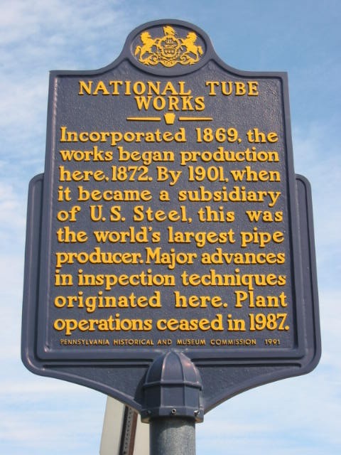 National Tube Works
N 40° 15.3762 - W 79° 47.6928 The historic marker reads; "Incorporated 1869, the works began production here, 1872. By 1901, when it became a subsidiary of U.S. Steel, this was the world's largest pipe producer. Major advances in inspection techniques originated here. Plant operations ceased in 1987." |
|
N 40° 21.076 - W 79° 51.925 |
|
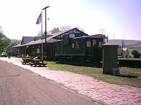
N40° 21.085 - W79° 52.101 The McKeesport trailhead is immediately off of Lyle Boulevard in McKeesport at the Eastern end of the 5th Avenue Bridge. There are no facilities here but a Get-Go convience store is two blocks into town (They told me they don't have a public restroom). The trail does not actually start at the parking lot. You must travel a few blocks down Water Street to the circle at the end of 9th Avenue.  LocalHikes.com Trail Report: McKeesport to Boston Google Maps on-road route to Eliza Furnace Trail |
|
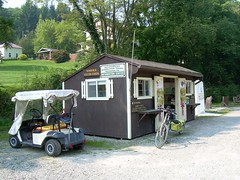
N40° 18.657 - W79° 49.675 The Boston trailhead is just off Route 48 at the south end of the Boston Bridge. Turn at the light onto W. Smithfield and then immediately right down to the parking lot. The Boston trailhead has water, restrooms and a seasonal snack and bike shop. LocalHikes.com Trail Report: Boston to Buena Vista |
|
N 40° 19.117 - W 79° 48.068 |
|
N 40° 18.884 - W 79° 47.507 |
|
N40° 18.730 - W79° 49.575 The Parking area at Twelve Field has a portajohn and a picnic pavillion but no water. |
|
N 40° 17.355 - W 79° 46.639 Primitive campground located over the hill from Dravo Cemetary. Water, restrooms and a picnic pavillion are located near the trailside. The nearby field was last known as the Philobaum pig farm before it was purchased by the Regional Trail Corporation. The area has been replanted with native grasses and there are plenty of bird houses as well. It is purported to have been a campsite of Senecca Queen Aliquippa, an important personage during the French & Indian War and friend of George Washington. |
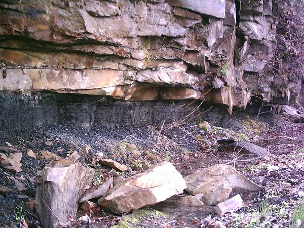
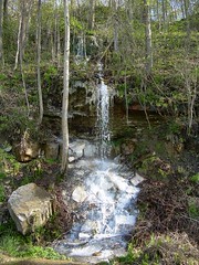 White Falls
N 40° 16.976 - W 79° 47.253 The white coating on the rocks is likely some sort of mine drainage from the Charleston Mine. |
|
N40° 16.786 - W79° 47.863 To get to the Buena Vista trailhead take Renzie Rd. South from the complex intersection in Boston. This becomes Buena Vista Rd. Turn left onto Styche St., right onto Muse and the left onto McGowan St. The trailhead has a toilet and picnic pavilion but no water. Not far down the trail (N40° 16.638 - W79° 47.858) is another parking area specifically for the Buena Vista boat launch. LocalHikes.com Trail Report: Boston to Buena Vista LocalHikes.com Trail Report: Buena Vista to Sutersville |
|
N 40° 16.172 - W 79° 48.761 The house is located beside the 18th green at Butler's Golf Course and can accommodate up to eight guests in our four bedrooms (click to see them), each with its own bath. 800 Rock Run Road, Elizabeth, PA 15037, 412-751-6670 John Butler House B&B Website |
|
N 40° 16.354 - W 79° 47.861 |
 Rusty Falls
N 40° 15.3762 - W 79° 47.6928 This nearly 20 foot tall formation is iron oxide runoff from the abandoned Pittsburgh Coal Company's Ocean No. 2 drift mine which operated from 1907 to 1932. |
|
N 40° 14.564 - W 79° 48.396 This ice cream store just up from the Sutersville trailhead has a picnic pavilion out back. |
|
N40° 14.464 - W79° 48.355 The Sutersville trailhead is accessable from the Irwin/North Huntingdon Turnpike Exit No. 67 via Rt. 30 West to Barns Lake Road. Turn left at the light onto Clay Pike to Rilton. Then turn right on Sutersville Road. The trailhead is just on the East side of the bridge across the Youghiogheny River. There are porta-johns but no water. An ice cream shop is open seasonally just up the street. Youghiogheny River gaging station at Sutersville LocalHikes.com Trail Report: Buena Vista to Sutersville LocalHikes.com Trail Report: Buena Vista to West Newton |
|
N40° 12.660 - W79° 46.223 - Elevation 769 ft. The West Newton trailhed is located on the West side of the bridge where Route 136 crosses the Youghiogheny River. The office of the Regional Trail Council is located just up the street in the basement of the Rite Aid building. There are also porta-johns and the West Newton Bike Shop. LocalHikes.com Trail Report: Sutersville to West Newton LocalHikes.com Trail Report: West Newton to Cedar Creek |
|
N 40° 12.677 - W 79° 46.236 Previously Korber's, the shop right on the trail is now under new management and a new name. 106 West Main Street, West Newton, PA 15089, 724-872-2185 |
|
N40° 10.638 - W79° 46.610 The Cedar Creek Park trailhead is just off Rt. 51 a quarter mile north of I-70 in Rostraver Township. There are rest rooms, water fountains, camping and a snack bar in addition to access to hiking trails within the park. LocalHikes.com Trail Report: West Newton to Cedar Creek LocalHikes.com Trail Report: Cedar Creek to Smithton |
|
N 40° 10.627 - W 79° 46.000 A reservation-free campsite that is almost plush. It has a toilet and water spigot, fire circles, half a dozen raised platforms for tents and a full adirondack shelter with a raised floor and fireplace. The county may periodically drop cut wood for campfires. |
 Port Royal Tufa
N 40° 10.402 - W 79° 45.831 Tufa is formed when calcite in limestone becomes enriched with carbon dioxide and forms carbonic acid, allowing water to dissolve the calcite present in the limestone layers. The tufa fossilizes leaves, twigs and living organisms that fall on the deposit. It is a sort of outdoor stalagtite that, in this case, may extend back 12,000 years. "Life frozen in stone", The Valley Independant, 29 May 2002 |
|
N40° 9.440 - W79° 44.796 The Smithton trailhead (mile 39.3) is accessed just south of the I-70 exit onto Route 51. Turn left onto Rt. 981 and the parking lot is list on the East side of the bridge across the Youghiogheny River. There is a porta-john available. LocalHikes.com Trail Report: Cedar Creek to Smithton LocalHikes.com Trail Report: Cedar Creek to Whitsett |
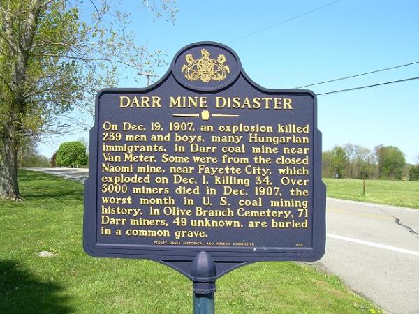 Darr Mine Disaster
N 40° 9.271 - W 79° 45.337 The marker reads: "On Dec. 19, 1907, an explosion killed 239 men and boys, many Hungarian immigrants, in Darr coal mine near Van Meter. Some were from the closed Naomi mine, near Fayette City, which exploded on Dec. 1, killing 34. Over 3000 miners died in Dec. 1907, the worst month in U.S. coal mining history. In Olive Branch Cemetery, 71 Darr miners, 49 unknown, are buried in a common grave." |
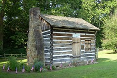
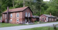 Whitsett House
N 40° 6.767 - W 79° 475.709 Built in the late 1800's by Ralph E. Whitsett, Sr., founder of the nearby mining town of Whitsett. |
|
N40° 6.443 - W79° 45.358 The Whitset trailhead is accessed off of Rt. 51 by turning East on Whitsett Hill Rd. South of Wickhaven. LocalHikes.com Trail Report: Cedar Creek to Whitsett LocalHikes.com Trail Report: Whitsett to Layton |
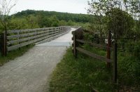
 SR4038 Crossing
N 40° 05.368 - W 79° 43.798 The trail passes under SR4038 as it comes out of a tunnel near Washington Run. Once a railroad throughway, it has been converted to a single-lane road. |
|
N40° 5.315 - W79° 43.771 The trailhead at Layton is accessed by following Layton Rd. out of Perryopolis and turning right just before the tunnel. The lot is just to the left at the bottom of the hill. LocalHikes.com Trail Report: Whitsett to Layton LocalHikes.com Trail Report: Layton to Dawson |
 Hazelbaker's Bottom Yough Outfitters
N 40° 5.402 - W 79° 43.525 Primarily a canoe rental business open mid-May through mid-October, they also have camp sites are $15 a night. You reach Hazelbaker's across the tunnel and SR4038 Bridge which is a single lane and fairly dangerous. Be careful. 654 Layton Rd., Perryopolis, PA 15473, 800-42-RIVER Hazelbaker's website |
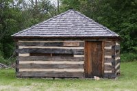 Fort Trial
N 40° 5.092 - W 79° 44.690 Replica of a c.1774 blockhouse used by Washington's partner for protection against hostile Native Americans during the two years the neighboring gristmill was being built. |
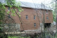 Washington's Grist Mill
N 40° 5.151 - W 79° 44.690 The historic marker reads: "George Washington owned 1643.5 acres in this vicinity. In 1774 the construction of Washington's Mill was begun but, owing to the trouble with the Indians and the outbreak of the American Revolution, the mill was not completed until the fall of 1776. Washington disposed of the mill in the fall of 1789 when he leased it to Colonel Israel Schreve for the term of five years. Israel entered into an agreement to purchase the mill in 1795 but died before the agreement could be finalized. Also located on this site is a restored bakery witch was here when the mill operated and the remains of a distillery which operated in conjunction with the mill." |
 Roundbottom Campsite
N 40° 4.371 - W 79° 43.666 Primitive campground with several adirondack-style shelters, several raised tent platforms, a toilet and water pump. |
|
N40° 2.714 - W79° 39.730 The trailhead at Dawson is accessed by exiting Rt. 51 onto Rt. 201 East. or leaving Connellsville on Rt. 201 West and turning North onto Rt. 819 in Vanderbilt. LocalHikes.com Trail Report: Layton to Dawson LocalHikes.com Trail Report: Dawson to Connellsville |
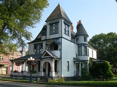 Cochran House
N 40° 2.773 - W 79° 39.292 The 12-room Victorian Style of William Cochran, brother of the owner of the Clifton and Jackson coal mines and coke works, James Cochran. The house is being refurbished for use as a Bed and Breakfast Inn. Reservations only. Tours available. Phone 724-529-2726. |
|
N 40° 2.488 - W 79° 37.556 More than 100 RV sites, 50 tent sites, two group site areas, and full-service cabin rental. It's been describved as "one of those "campgrounds" that is more of a trailer park with people that live there full time and have concrete patios and such." Expect plenty of noise late into the night. Trail users are welcome to use the camp store for ice cream, snacks and drinks. Public restrooms are also available to trail users. Campers coming off the bike trail qualify for a 50% discount off camping rates. Reservations not required. River's Edge Campground website |
 Overholt Distillery Swinging Bridge
N 40 2.740 - W 79 36.756 Suspension bridge for employees of the A. Overholt & Co. Distillery in Broad Ford on the east shore of the Youghiogheny to travel to and from their homes in Adelaide on the west shore. |
 Colonel William Crawford's Cabin
N 40 1.221 - W 79 36.036 William Crawford (1732 – 11 June 1782) was an American soldier and surveyor who worked as a western land agent for George Washington. Crawford fought in the French and Indian War and the American Revolutionary War. This is a replica of his home built near this site along Braddock's Road in 1765. |
|
N40° 1.211 - W79° 35.985 - Elevation 905 ft. Connellsville has several places to park and access the trail. Most notably, is Riverfront Park at the end of North 6th and North 7th Streets off of Route 711. The park has rest rooms, picnic pavilions water and access to other shops and snacks. There is also parking off of North 3rd St.  Youghiogheny River gaging station at Connellsville LocalHikes.com Trail Report: Dawson to Connellsville LocalHikes.com Trail Report: Connellsville to Camp Carmel Maps of Lower Yough Rapids LocalHikes.com Trail Report: Camp Carmel to Ohiopyle |
 Bicycles Unlimited
N 40° 01.021 - W 79° 35.754 503 West Crawford Avenue, Connellsville, Pa. 15425, 724-628-2453 Bicycles Unlimited website |
|
N 40° 00.986 - W 79° 36.025 Typical convenience store. |
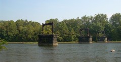
 Greenwood Bridge
N 39° 0.005 - W 79° 36.024 Also identified as Bridge 252.9, it is a deck plate girder bridge, 731.5 feet in length. The designation indicates that it was 252.9 miles from Baltimore, MD on the Western Maryland Railroad. |
 Bowest Bridge
N 39° 59.647 - W 79° 35.767 Also identified as Bridge 252.6, it is a deck plate girder and through truss bridge, 746.9 feet in length. |
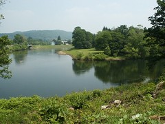
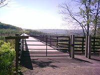
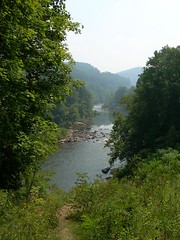 Youghiogheny River Overlook
N 39° 56.267 - W 79° 29.433 Scenic overlook near the Northern end of Ohiopyle State Park, looking South towards Johnson Run. The little jog in the trail is because of Texas Eastern's pipeline. This particular line connects a pumping station at Berne, OH with Chambersburg, PA., part of a network from Texas to the Northeast |
|
N 39° 52.911 - W 79° 29.743 This campsite is 4/10 off the trail and up a fairly steep hill (+275' of elevation). There is a water spigot (in season) and a large number of fire circles with picnic benches. There are restrooms and showers nearer the center of the campground but this particular set of campsites are on the fringe. Costs for these sites are $12-$14 Sun -Thur. and $15-$17 Friday-Sat, per night depending on whether you live in PA. Reservations are available from Ohiopyle State Park (888-PA-PARKS or www.visitpaparks.com). |
 Ohiopyle Trailhead
N39° 52.186 - W79° 29.524 - Elevation 1230 ft. The Ohiopyle trailhead is at the Visitor Center just off Route 381. Rest rooms, restaurants, hotels, campsites, boat rentals and 79 miles of trails plus the Laurel Highlands Hiking Trail. Youghiogheny River gaging station at Ohiopyle LocalHikes.com Trail Report: Connellsville to Camp Carmel LocalHikes.com Trail Report: Camp Carmel to Ohiopyle Maps of Lower Yough Rapids LocalHikes.com Trail Report: Ohiopyle to Confluence Maps of Middle Yough Rapids |
 Wilderness Voyageurs
N 39° 52.291 - W 79° 29.524 Primarily divoted to whitewater rafting, the shop has plenty of resources for the outdoors; hiking, camping and bike rental during the season. 103 Garrett St, Ohiopyle, PA 15470, phone 800-272-4141 Wilderness Voyageurs website |
|
N39° 49.566 - W79° 22.736 Youghiogheny River gaging station at Ramcat |
 Turkeyfoot
N 39° 48.928 - W 79° 21.964 Lt. Col. George Washington camped here on 20 May 1754 while seeking a navigable water route to the Forks of the Ohio (Pittsburgh) where the French were building Ft. Duquesne. His orders were to proceed to the mouth of Redstone Creek (Brownsville) and await reinforcements before striking the French. The formidable rapids ten miles downstream caused Washington to abandon the route and turn westward over the mountain. |
|
N39° 48.440 - W79° 21.785 The Confluence trailhead is behind the Riversport shop on the Eastern side of the Rt. 281 bridge. There are porta-johns at the lot but no water available at the shop. Camping facilities (and water) are available further up towards the Youghiogheny River Dam. Shops and restaurants are available in the town of Confluence itself.  Youghiogheny River gaging station at Dam Outflow LocalHikes.com Trail Report: Ohiopyle to Confluence LocalHikes.com Trail Report: Confluence to Ft. Hill |
|
N39° 49.550 - W79° 16.534 The trailhead at Ft. Hill can be access off of Rt. 281 North from Confluence. Turn South onto Ft. Hill Rd. and the parking is just before it joins T.368. LocalHikes.com Trail Report: Confluence to Ft. Hill LocalHikes.com Trail Report: Ft. Hill to Markleton |
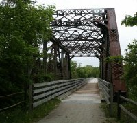
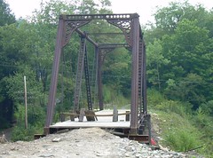
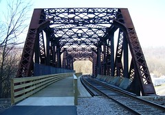
 Pinkerton High Bridge
N 39° 50.405 - W 79° 14.950 |
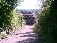
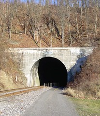
 Pinkerton Tunnel (West Portal)
N 39° 50.448 - W 79° 14.873 The trail makes a 1.5 mile bypass around the Pinkerton Horn because the 849 feet of tunnel is impassable. The tunnel was originally lined with wood to save money but the tunnel caught fire in 1879. RAther than repairing the tunnel, a "shoofly" was built around Pinkerton Horn (the trail currently follows this route). The tunnel was rebuilt with brick in 1885. |
 Pinkerton Tunnel (East Portal)
N 39° 50.449 - W 79° 14.875 The facing of the tunnel reads "1911" though the rest of the tunnel was built (and rebuilt) decades before. |
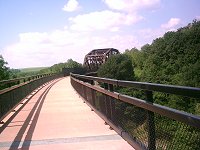
 Pinkerton Low Bridge
N 39° 50.563 - W 79° 14.664 |
|
N39° 51.604 - W79° 13.663 The Markleton trailhead can be accessd off of Rt. 281 North from Confluence. Turn East onto Markleton School Rd. Left on Turkeyfoot Trail Rd and then immediately right onto State Rd. 3011. Casselman River gaging station at Markleton LocalHikes.com Trail Report: Ft. Hill to Markleton LocalHikes.com Trail Report: Markleton to Rockwood |
 Rockwood Trailhead
N39° 54.661 - W79° 9.680 - Elevation 1826 ft. The trailhead at Rockwood Station is accessed by taking Rt 653 to Rockwood. There, it makes a hard left turn. Follow Bridge St. straight across the Cassleman River to the parking area just on the South side. Rockwood has a portajohn and a water fountain and the Sembower Visitor Center oftentimes manned by Maynard Sembower himself. Horses are permitted on the grassy half of the trail between Rockwood and Garrett.  LocalHikes.com Trail Report: Markleton to Rockwood LocalHikes.com Trail Report: Rockwood to Garrett |
 Rockwood Trail House
N 39° 54.642 - W 79° 9.639 Restored, turn-of-the-century, colonial home offers modern day conveniences combined with farmland antiquities at 131 Rockdale Rd, Rockwood, PA. 15557, 888-916-2453. It has five guest rooms at $85.00 per night, a country breakfast served about 8:00 and bike rentals. Rockwood Trailhouse Website |
|
N 39° 54.750 - W 79° 9.599 |
 Rockwood Mill Shoppes & Opera House
N 39° 54.841 - W 79° 9.455 450 West Main Street, Rockwood, PA 15557, 814-926-4546 Listed on the National Register of Historic Places, this century old lumber and feed mill now hosts more than 15 retail vendors and services. A restaurant serves pizza, baked goods, coffee and ice cream. The old Opera House in the upstairs section of the building stages a variety of musical entertainment and can be rented for special events. There is a fitness center and tanning beds. http://rockwoodmillshoppes.com/ |
 Lower Kittanning Coal Seam
N 39° 54.698 - W 79° 9.475 Some 300 Million years ago, Pennsylvania was much further south than it is now, almost at the equator. This whole region was a costal-plain delta with peat swamps. These thick layers of peat were covered and compressed into this fairly narrow layer of coal. Even though it was difficult to mine, the Industrial Revolution's appetite for coal pushed miners to work this seam in spaces no higher than that under your desk. This location is marked with a wooden post labled A-GR9 and is part of the K-12 geology course plan developed by the Bureau of Topographic and Geologic Survey, the DCNR, and the Somerset County Rails to Trails Association. From Rails to Trails to Rocks: Student Trail Guide |
|
N 39° 54.727 - W 79° 9.229 The rusty-colored stream is polluted mine runoff. AMD or Acid Mine Drainage is caused by water and oxygen reacting with pyrite exposed during the mining process. The acidic content of the water is similar to that of lemon juice. This location is marked with a wooden post labled B-GR8. From Rails to Trails to Rocks: Student Trail Guide |
|
N 39° 54.735 - W 79° 9.041 The large pile of dark material is waste rock produced during mining on the Lower Kittanning coal seam. This location is marked with a wooden post labled C-GR7. From Rails to Trails to Rocks: Student Trail Guide |
|
N 39° 54.280 - W 79° 8.459 The curve of the anticline brings the bed of the Homewood Formation of the Pottsville Limestone and the associated rhododendrons back down to trail level. Fossil Sigillaria, large scaly trees, can be found in the lower layers of this bed. This location is marked with a wooden post labled D-GR6. From Rails to Trails to Rocks: Student Trail Guide |
|
N 39° 53.357 - W 79° 7.465 Off the trail is a section of the Mauch Chunk Formation that sits just above the Wymps Gap Limestone layer. This location is marked with a wooden post labled E. From Rails to Trails to Rocks: Student Trail Guide |
|
N 39° 53.281 - W 79° 7.394 During the Mississippian Period about 330 Million Years ago Western Pennsylvania was the shore of a shallow sea. The exposed limestone layers are a fairly thin band of fossil bearing rock sandwiched between layers of shale. This location is marked with a wooden post labled F-GR5. From Rails to Trails to Rocks: Student Trail Guide Common Fossils of Pennsylvania DCNR Fossil Plates |
|
N 39° 52.779 - W 79° 6.803 A stream bed that has cut down to expose the oldest layers along the trail. While it is difficult to see, it's not as far off the trail to see these stones. This location is marked with a wooden post labled G. From Rails to Trails to Rocks: Student Trail Guide |
|
N 39° 52.700 - W 79° 6.363 200 Million years ago when North America ran into Africa, what is now the east coast folded up like an accordion, (The Alleghenian orogeny) creating the current generation of the Allegheny Mountains. This point would mark the high point of the Negro Mountain fold along the trail except that Lick Run has eroded away the hundreds of feet of rock to reveal the oldest rock along this section of trail. You'll see that the layers of the Burgoon Sandstone in the creek bed lie horizontally. This location is marked with a wooden post labled H-GR4. From Rails to Trails to Rocks: Student Trail Guide |
 Festooned Crossbedding
N 39° 52.795 - W 79° 5.603 The thick grey sandy limestone is known as the Loyalhanna Member of the Mauch Chunk Formation. The ripples are essentially petrified sand dunes and the abrupt changes in directions were caused by weather differences, the wind blowing the waves in another direction, re-aligning the sand beneath the waves. This location is marked with a wooden post labled I-GR3. From Rails to Trails to Rocks: Student Trail Guide |
|
N 39° 52.500 - W 79° 5.099 A "colony" of Rhododendron marks the location of an ancient landslide that brought Pottsville Limestone and upper Mauch Chunk Formation down from over 300 feet up the hillside some 10,000 years ago. This location is marked with a wooden post labled L-GR2A. From Rails to Trails to Rocks: Student Trail Guide |
|
N 39° 52.276 - W 79° 4.640 Several hundered feet below the Pottsville Sandstones are thinly layered, olive-grey siltstones, sandstones and limestones, or reddish-brown silty claystones. Something else you will notice is the disappearance of Rhododendrons. These plants flourish in the acidic soils derived from the Allegheny Formation, Pottstown limestones and the upper parts of the Mauch Chunk Formations. But the lower parts of the Mauch Chunk are more alkaline and the Rhododendrons don't do so well here. This location is marked with a wooden post labled K-GR2. From Rails to Trails to Rocks: Student Trail Guide |
|
N 39° 52.172 - W 79° 4.242 Across the Youghiogheny River, Piney Run has over thousands of years washed a broad fan of debris into the river. This location is marked with a wooden post labled L. From Rails to Trails to Rocks: Student Trail Guide |
|
N 39° 52.182 - W 79° 4.082 The rocks making up these boulders formed about 310 Million years ago during the Pennsylvanian Period. At the time, the Appalachian Mountains were granite monsters, higher than the Himilayas are today. Erosion washed the mountains into the shallow sea that once was here where the granite bonded in the silica-rich waters to form a very strong 200 ft thick layer. 100 Million years later, the Alleghenian orogeny created a new mountain range on the grave of the old. The harder Pottstown survived the weathering much better than the softer surrounding stone. These particular boulders broke free of the layer during the last ice age and from 24,000 to 18,000 years ago have been working their way down the slope. This location is marked with a wooden post labled M-GR1. From Rails to Trails to Rocks: Student Trail Guide |
|
N39° 54.661 - W79° 9.680 A simple parking area at the Brant Landing boat launch. |
|
N39° 51.626 - W79° 3.786 The Garrett trailhead is accessed by taking Rt. 219 South from the Somerset exit of the PA turnpike. Turn right onto Rt. 653, left onto Walker St., Right onto Jefferson St. then left onto Berlin St. (SR2037) and across the bridge to the parking areas just on the other side. The trailhead has a portajohn but no other facilities. Horses are permitted on the grassy half of the trail between Garrett and Rockwood. LocalHikes.com Trail Report: Rockwood to Garrett LocalHikes.com Trail Report: Garrett to Meyersdale |
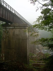
 Salisbury Viaduct (West)
N 39° 50.110 - W 79° 2.839 With a length of 1,908ft, the viaduct spans the Casselman River Valley, Rt.219, the B&O, and the Casselman River. Salisbury Viaduct/B199.4 |
 Meyersdale Station
N39° 51.626 - W79° 3.786 - Elevation 2106 ft. Meyersdale Station is accessed off of Business Rt. 219, up Main St on the left just after crossing active rail and past Chestnut St. There's a handicap accessable portajohn and a Visitors Center. Restaurants and hotels are located down the hill in Meyersdale. LocalHikes.com Trail Report: Rockwood to Meyersdale LocalHikes.com Trail Report: Meyersdale to Deal |
 Bollman Bridge
N 39° 49.096 - W 78° 59.692 The bridge built in 1871 is a Warren truss with cast- and wrought-iron members and a wooden deck. It is 81 feet long and 13 feet wide. It originally carried the railroad's line to Pittsburgh over Wells Creek. About 1910, the increasing weight of trains dictated that it be replaced. This span was recycled to carry a farm road over the B&O (now CSX) mainline. In 2003, the state wanted it demolished but it will be recycled yet again. It was lifted from its moorings on the west side of Meyersdale in May of 2006, Was moved to it's location over Scratch Hill Road in July of 2007 and will be connected to the trail by 2008. "Daily American" news article, 4 Nov 2005 |
 Keystone Viaduct (Northern Approach)
N 39° 48.700 - W 78° 59.771 Officially designated as Bridge 195.5 (195 miles from Baltimore, MD), the Keystone Viaduct curves to the left and the through steel truss becomes a simple plate girder span. When the bridge was being refurbished, they knocked out two bridge piers to straighten Glade City Rd. beneath and replaced the three girder structure with a single 240 ft long girder. All told, Keystone Viaduct is 910 feet in length. |
 Keystone Viaduct (Southern Approach)
N 39° 48.551 - W 78° 59.670 |
|
N39° 47.740 - W78° 58.521 |
|
N39° 46.706 - W78° 57.280 Keep an eye out for a friendly "trail kitty" named Nola that lives neary. |
|
N39° 45.686 - W78° 55.839 The parking area at Deal has a handicap accessable portajohn but no other facilities. When the Big Savage Tunnel is closed for the Winter (between about mid-December to mid-April) you will need to leave the trail here and take to the road to cover the 11 miles to Frostburg. LocalHikes.com Trail Report: Meyersdale to Deal LocalHikes.com Trail Report: Deal to Frostburg Google Maps winter bypass between Deal and Frostburg |
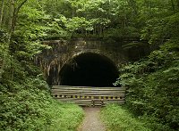
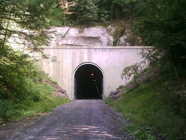 Western Portal of the Big Savage Tunnel
N 39° 44.722 - W 78° 53.788 The Big Savage Tunnel is 3300 feet in length. It has doors at either end that are to be closed from mid-December to mid-April to keep the cold winds from causing icing issues with the lining. $13 Million was spent rehabbing the tunnel and they don't want ice to break apart all the fine work they've done. It's mostly straight but has a slight bend at the eastern portal. Lights have been installed. |
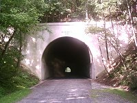
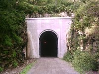 Eastern Portal of the Big Savage Tunnel
N 39° 44.235 - W 78° 53.471 Just outside the Eastern portal is a terrific view into the valley. |
|
N 39° 44.137 - W 78° 53.440 At the Eastern portal of the Big Savage Tunnel is an expansive view with the town of Mount Savage to the South, Jennings Run and beyond that the Wills Creek Narrows to the Southeast. From here it is an average of a 1.75% grade down past Frostburg to the State Line Bridge. |
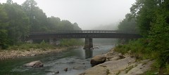
 Southern portal of Borden Tunnel
N 39° 41.259 - W 78° 55.195 Built in 1911, the tunnel was bored for two tracks and has a length of 957.5 feet. |
|
N39° 39.552 - W78° 55.315 - Elevation 1832 ft. The Frostburg trailhead has a handicap accessable portajohn and a large information board. Nearby restaurants, B&Bs and the Depot for the Western Maryland Scenic Railroad are up a substantial switchback. When the Big Savage Tunnel is closed for the Winter (between about mid-December to mid-April) you will need to leave the trail here and take to the road to cover the 11 miles to Deal.  LocalHikes.com Trail Report: Deal to Frostburg Google Maps winter bypass between Frostburg and Deal LocalHikes.com Trail Report: Frostburg to Woodcock Hollow |
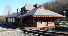 Frostburg Depot
N 39° 39.451 - W 78° 55.419 The C&P Railroad Depot was built in 1891 and is the only survivor among 12 built along the line, which primary carried coal from Georges Creek to points east. Today it is the terminus of the Western Maryland Scenic Railroad. The train comes up from Cumberland and the engine is spun on the turnstile for the return trip. Western Maryland Scenic Railroad website |
 Trail Inn & Cafe
N 39° 39.438 - W 78° 55.476 Originally built as the Tunnel Hotel in the mid-1800s, the Trail Inn has eight rooms with occupancy ranging for $69-$99 for double occupancy, breakfast included. The entire third floor sleeps 8 with kitchen and bath is available for $140-$160. Wireless internet access available. 20 Depot St. Frostburg, Maryland 21532, Phone: 301-689-6466 Trail Inn & Cafe Website |
|
N 39° 39.450 - W 78° 55.476 Adjacent to the Trail Inn & Cafe. |
|
N39° 40.957 - W78° 51.3335 - Elevation 1300 ft. There is a small parking lot at Woodcock Hollow with room for three vehicles. There are no facilities at the lot itself but a stone's throw West is a picnic pavillion and a handicap accessable portajohn. LocalHikes.com Trail Report: Frostburg to Woodcock Hollow LocalHikes.com Trail Report: Woodcock Hollow to Cumberland |
 Brush Tunnel (Eastern Portal)
N 39° 41.336 - W 78° 48.828 Built in 1911, it stands at mile B172 of what was once the Western Maryland Railroad. The old mile marker is still just outside the western portal. |
 State Line Bridge
N 39° 40.205 - W 78° 47.434 Also known as the Ekhart Junction Bridge. |
|
N39° 39.295 - W78° 46.125 Dedicated trail access parking area accessed off of North Lee Street in Cumberland. It's probably better parking here than trying to find a place within Cumberland itself. |
|
Cumberland Trailhead N39° 38.949 - W78° 45.781 - Elevation 620 ft. Mile 0 of the Great Allegheny Passage is mile 184 of the C&O Canal Towpath which extends into Georgetown in Washington DC.  Wills Creek gaging station near Cumberland LocalHikes.com Trail Report: Woodcock Hollow to Cumberland C&O Canal GPS Coordinates: Continue on to Washington, DC |
Water Pumps, Fountains, Spigots and Vending Machines
|
N 40° 18.671 - W 79° 49.665 Fountain at Boston Trailhead N 40° 17.322 - W 79° 47.691 Pump at Dravo Cemetary N 40° 12.742 - W 79° 46.173 Fountain at West Newton Trailhead N 40° 10.615 - W 79° 46.035 Spigot at Cedar Creek Camp N 40° 04.381 - W 79° 43.662 Pump at Roundbottom Camp N 40° 01.236 - W 79° 35.912 Spigot at Connellsville N 39° 52.195 - W 79° 29.524 Spigot at Kentuck Campground |
N 39° 52.195 - W 79° 29.524 Vending Machines at Ohiopyle N 39° 48.319 - W 79° 22.004 Spigot at Yough Dam Campsite N 39° 54.653 - W 79° 09.700 Fountain at Rockwood Trailhead N 39° 52.846 - W 79° 06.010 Spring at Negro Mountain N 39° 48.997 - W 79° 01.263 Vending Machines at Meyersdale N 39° 38.954 - W 78° 45.777 Fountain at C&O Trailhead N 39° 38.816 - W 78° 45.786 Fountain at C&O Canal |
Portajohns and Rest Rooms
|
N 40° 18.643 - W 79° 49.718 Restroom at Boston Trailhead N 40° 18.844 - W 79° 49.323 Portajohn at Harper Street N 40° 18.854 - W 79° 47.546 Portajohn at River City Jct. N 40° 12.742 - W 79° 46.173 Portajohn at Twelve Field N 40° 17.303 - W 79° 46.668 Restroom at Dravo Cemetary N 40° 16.763 - W 79° 47.866 Toilet at Buena Vista N 40° 16.082 - W 79° 47.618 Portajohn at Industry N 40° 14.865 - W 79° 48.061 Portajohn at Blythedale N 40° 13.570 - W 79° 46.222 Portajohn at Collinsburg N 40° 14.464 - W79° 48.355 Portajohn at Sutersville Trailhead N 40° 12.673 - W 79° 46.229 Portajohn at West Newton Trailhead N 40° 10.637 - W 79° 46.611 Restroom at Cedar Creek Station N 40° 10.606 - W 79° 46.020 Toilet at Cedar Creek Camp |
N 40° 06.456 - W 79° 45.385 Portajohn at Whitsett N 40° 04.328 - W 79° 43.657 Toilet at Roundbottom N 40° 01.232 - W 79° 35.902 Restroom at Connellsville N 39° 51.559 - W 79° 13.639 Portajohn at Markleton Trailhead N 39° 54.653 - W 79° 09.695 Portajohn at Rockwood Trailhead N 39° 51.618 - W 79° 03.778 Portajohn at Garrett Trailhead N 39° 49.028 - W 79° 01.324 Portajohn at Meyersdale (handicap) N 39° 45.684 - W 78° 55.879 Portajohn at Deal (handicap) N 39° 44.183 - W 78° 53.445 Portajohn at Big Savage Tunnel N 39° 40.180 - W 78° 55.373 Portajohn above Frostburg N 39° 39.573 - W 78° 55.312 Portajohn at Frostburg (handicap) N 39° 40.936 - W 78° 51.408 Portajohn at Woodcock Hollow (handicap) |
Mile Markers
|
N 40° 18.388 - W 79° 47.970 Mile 125 N 40° 16.353 - W 79° 47.846 Mile 120 N 40° 13.612 - W 79° 46.409 Mile 115 N 40° 10.571 - W 79° 46.346 Mile 110 N 40° 07.340 - W 79° 45.207 Mile 105 N 40° 04.713 - W 79° 43.098 Mile 100 N 40° 03.076 - W 79° 40.527 Mile 95 N 40° 03.076 - W 79° 40.527 Mile 90 N 39° 58.429 - W 79° 34.914 Mile 85 N 39° 57.437 - W 79° 29.894 Mile 80 |
N 39° 54.193 - W 79° 29.265 Mile 75 N 39° 50.321 - W 79° 28.039 Mile 70 N 39° 50.602 - W 79° 23.829 Mile 65 N 39° 47.816 - W 79° 20.676 Mile 60 N 39° 49.679 - W 79° 17.346 Mile 55 N 39° 51.482 - W 79° 13.600 Mile 50 N 39° 54.381 - W 79° 11.127 Mile 45 N 39° 52.826 - W 79° 06.886 Mile 40 N 39° 50.908 - W 79° 03.497 Mile 35 N 39° 39.736 - W 78° 55.024 Mile 15 N 39° 41.301 - W 78° 51.439 Mile 10 |
| http://www.tasigh.org/wotgap/coordinates.html -- Revised: 30 September 2007 Copyright © 2005-2007 Kevin A. Geiselman |