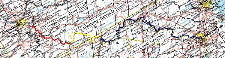
In 1999, I rode the Youghiogheny River Trail, Allegheny Highlands Trail and C&O Canal Towpath from near McKeesport, PA to Washington, DC. This trip of some 320 miles was done in an insane three days. An impressive feat that left no time for sightseeing.
In 2003, I decided to do the entire trip again. But this time I was going to take a "leisurely" four days. Averaging 80 miles a day at 10 mph would allow what I thought to be ample time to sightsee and geocache along the way.
You will forgive me if this tale is somewhat overly focused on geocaching. To begin this document I pulled the logs from each cache along the way and compiled them together. I've deleted some things that were more relevant to geocaching and less interesting to the general reader. Also, I have added some descriptions that my be spoilers for any geocachers. Nothing too revealing, though.
And so it began.
Thursday 26 June
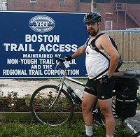
My ride began at 7:00 am at the "Little" Boston Trailhead where my wife took a picture of me standing at the sign so that I could log the Trail from Rails locationless cache. My plan was to ride the 100 miles to Meyersdale and spend the night at a hostel there.
The 40 miles between Boston and Connellsville was fairly uneventful. I ride this section of trail often and had already logged all the caches and benchmarks on this section on previous trips so I didn't make any stops along the way.
There is a totem pole in Connellsville's Riverside Park. I think it's very odd to find a totem pole in Western Pennsylvania, as they are native to the American Northwest. I don't know the history of the pole but I suspect that the Boy Scouts are responsible. Firstly, there are plaques in the park placed by the scouts explaining the history of the region and the creation of the park. And while the plaques say nothing about the totem pole, the Boy Scouts have a sort of faux Indian sub-culture that would put a Northwestern-native totem pole along the banks of the Youghiogheny River. As an Eagle Scout and recipient of the Order of the Arrow I would like to think that, given the opportunity I would try to find some way to recognize the local natives.
Culturally relevant or not, this pole is good enough to log the Totem Pole locationless geocache.
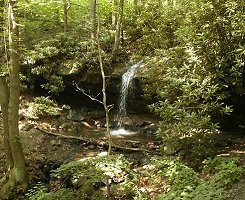 A short way south of Connellsville is a nice little waterfall. I logged it as the Beauty of Waterfalls locationless cache. I tried setting up my digital camera on a bench and then running down to be in the photo for scale but 9 seconds just wasn't enough time. I nearly threw myself into the pool in the attempt.
As I approached the Northern border of Ohiopyle State Park, I ran across several gentlemen in need of assistance. One of them was dealing with his second flat tire and was in need of a more substantial bike pump. I had such a thing so, as I assisted them we discussed our days. They were surprised to hear that I had started in Little Boston 5 hours earlier, was planning to get to Meyersdale before day's end and was then off to DC by Sunday. They were from Frostburg (I expected to ride by there the next day) and while they had ridden much of the C&O and Allegheny Highlands Trail, they had done so in short day trips.
The Falls City geocache is about 16 miles south of Connellsville and just before the bridges over the "loop" at Ohiopyle. This was my first "real" cache of the day and I found it in relatively short order not far off the trail. It made me a little nervous to leave my bike just leaning against a tree but I was not about to drag my heavy Kryptonite lock along on this ride and figured pulling it off the trail would be good enough.
I ride the trail often but seldom get above Connellsville. I should change that because the area around Ohiopyle is very nice. The water is faster and you can always hear it splashing through the rapids. I also think that there are fewer bugs here than in the lower, calmer reaches.
I stopped at the Visitor Center at Ohiopyle for lunch. Actually, I first got down off the trail to log a benchmark (JW0588) on the bridge where Route 381 crosses the Youghiogheny. There was supposed to be another benchmark on the near side of the bridge but I couldn't find it.
Ten miles further South is where the Youghiogheny River Trail connects to the Allegheny Highlands Trail at Confluence. At the trail entrance is a shop which seems to specialize in river and hiking sports. The proprietor seemed surprised that I was asking about obtaining some water. He let me use the hose he had out back to wash off the kayaks.
I think that one of the failings of the Yough and Allegheny Highlands Trails are the lack of facilities, even as simple as a place to get water. The Boston trailhead has a fountain but the next place to get water is 20 miles down at Cedar Creek and the next is Connellsville 20 miles beyond that. The Round Bottom Campsite is midway between Cedar Creek and Connellsville but I don't recall seeing a water pump there. And there is nothing for the 30 miles between Confluence and Meyersdale. If I didn't have a three-liter Camelbak (filled three times on that day), I might have been really hurting for water.
The Casselman Cache is about 25 miles up the Allegheny Highlands Trail above Confluence. I was able to move off the path and find the cache in reasonably short order. Very buggy. It was so nasty that I walked in circles while writing in the log and going through the cache contents. Just that little bit of breeze kept the mosquitoes from landing.
I skipped the Windmills Geocache outside of Garrett because I was starting to get tired and was not interested in making the detour necessary to get up to the Green Mountain Wind Farm. It was just a touch less than 2 miles but after 100 miles, I was looking forward to the end of my day.
After crossing the Salsbury Viaduct, the trail quality declined markedly up to Meyersdale Station. No improvements to this section had been made since my visit in 1999. Figuratively speaking, things went downhill from there.
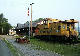
I took a picture of the station so that I could log it at the Railroad Depots locationless cache. I was going to take the requisite picture of my GPSr in the frame to prove that this wasn't just a vacation photo when my camera ceased to function. I kept turning it off and on to the same result. I tried removing and reinserting the batteries to no success. Eventually, the camera started making a ratcheting sound and I gave up.
The camera had a similar problem two months previously and had already been back for service at Minolta so I was terribly unhappy. Especially because I was running out of time on my warranty period.
The frustrations continued as the Meyersdale Hostel at which I intended to spend the night was locked up tight. I considered sleeping on the lawn at the Meyersdale Station but it was too hot to be in the sleeping bag and too buggy not to be so protected (a theme that would drive me through the whole weekend). So, as night fell, I decided to ride on.
Except that the route I was going to take had a big "Road Closed" sign. The detour was taking me North instead of South and I figured that it was going to eventually put me onto a highway where I couldn't take my bike. I set off in the other direction but eventually came across another highway ramp that I couldn't travel. I was trapped in Meyersdale.
My wife would be on her way to my sister's in Maryland to pre-position herself to pick me up on Sunday at trail's end, so, while I was despondent about aborting the endeavor or making her detour to rescue me, I tried to call her. Except that I couldn't get a cell phone signal. I remembered a sign while leaving Confluence that said "No Cell Phone Coverage Next 30 Miles". Well, Meyersdale was part of that zone as well. I had to ride back another mile to find a convenience store with a pay phone.
While I was on the phone with my wife, who had already arrived at my sister's, a local police officer pulled into the station to get gas. He told me of a way around the bridge construction by taking a side road and connecting up to the railroad maintenance road. Apparently all the locals in the area use this bypass to the point where the police overlook the "trespassing on railroad property" issue. I called my wife back to tell her I was on the move again. This was 11 pm.
After that it was along winding hills, in the dark. My LED headlamp served me very well. It was a perfect temperature and the road was smooth but after putting over 100 miles in the saddle already I was not moving very quickly. For a lot of the way I was walking rather than riding.
By 3 am I was at the top of Big Savage Mountain which was only half-way to Cumberland. It was about 16 miles down into Cumberland and another 10 miles or so beyond that to get to a decent camp site along the C&O so I decided to lay out my sleeping bag in the tall grass next to a truck brake-check station. The stars were bright, there was a constant, cooling breeze and there were no bugs.
Friday 27 June
I got up at about 7am Friday morning and started down the mountain. I had looked at a decent map and, with the aid of my GPS I found the proper turn to in Frostburg so that I didn't have to take Rt 40 into Cumberland as I had in 1999. My first stop was the Bone Cave cache. It was a short way off on a side road where I parked my bike and climbed up a steep hill to the Western Maryland Railroad and the future track of the Allegheny Highlands Trail. Bone Cave was discovered in 1912 when the Western Maryland Railroad was being cut through the hilside and it was a treasure trove of Pleistocene fossils including mammoths and sabre-tooth cats. Today, however, it is a garbage pit for vandalous youths. I found the cave that was described but the cache was on the other side of the tracks. I climbed up the large rock formation. Climbed down. Up again and all around for quite a long time without finding the cache. I must have spent nearly an hour without success. Disappointed, I went back to my bike.
Only after arriving home did I have the chance to check the website and learned that it had been archived. It had probably been plundered months before. The mistake is that I had been building the EasyGPS.loc file over the course of several months and neglected to check on the disposition of each cache just before leaving for my trip.
I continued down through the Gap into Cumberland and began searching for the Fort Cumberland virtual cache. The coordinates lead me to a parking lot where I found no signage to point me in the direction of an answer. It's pretty disappointing to not be able to find a virtual cache. Of course, only after returning from my trip and reading the other logs did I realize my mistake. Apparently one interpretive sign leads to another and then to another and the answer is found on the last sign. Since I didn't see a sign at the first coordinates, I didn't realize that the other signs were part of the sequence and thus didn't follow them to the end.
My ride continued the 30-plus miles from Cumberland to the Tunnel Hill Trail cache at the Paw Paw Tunnel. I parked my bike and started up the path, counting my steps along the way. I never found the observation area but there was a side path that I didn't take. Two miles later I came back down on the other side of the tunnel. In the canal along with all the little fish were several little poisonous snakes. A pair of little Copperheads and what I think was a small Cottonmouth. I gathered up my bicycle and went back through the tunnel on my way south. As I rode away I continued to have the nagging feeling that I had done it all wrong.
Once I got home and read the logs I realized that the "observation area" at the tunnel was in fact over the mouth of the tunnel. What I thought were retaining stones were actually the steps up to the top of the tunnel. I had turned a simple exercise in counting into a 2 mile treck over the mountain that the canal builders had so helpfully bored straight through. And I still didn't know how many steps there were.
Thankfully, the cache owner responded to my e-mail, saying that even though I didn't properly count the steps, my tale of woe was proof enough that I was actually at the right location. I was able to log the cache as "found".
This was also my last cache attempt for the day. I skipped the I Wonder What This Was cache because I didn't have the cache description and Lil' Orleans because it was too much of a detour to get across the canal and climb the hill. I rode another 30 miles for the day and spent the night sleeping on a park bench at the trail camp at Hancock.
Saturday 28 June
It was 65 miles to the Pterodactyl mountain exploration #1 cache. At least, to the base of the hill. I took the wrong route across the highway and began the long climb up the hill, leaving my bike at the bottom. Once at the overlook I again cursed my camera having broken on Friday so that I could not document the spectacular view. I imagined Union soldiers during the Civil War looking out over the Confederate troop movements across the Potomac and felt sorry for the messenger who had to carry that information down the hill to Harper's Ferry.
I searched one area without success. I looked at another, also without success. I went back to my starting point to get a better satellite signal and searched again without success. I decided not to rely on my GPSr and began to widen my search. But under the next rock overhang I came face to face with a big, beautiful COPPERHEAD. Alone, on top of the mountain I decided not to go poking around under any more rocks lest I irritate the locals. I abandoned my search and went back down.
Four years ago, I rode the C&O Canal Towpath and saw the Monocacy River Aqueduct in the daylight and it was an impressive structure. On this trek I arrived at the aqueduct at about 10:00 at night. Even with the bright headlamp, I could not see very well beyond the chain-link fencing surrounding the rehabilitation construction area. I was unable to find the benchmark but it's often difficult to find those things in the daylight so I didn't spend a whole lot of time in the search.
I clomped my bike across the brackets apparently bolted to help hold the structure together and past the guys fishing off the span on my way to the Marble Quarry rest area. I settled down and crawled into my sleeping bag to try to get some sleep. It was far too hot to curl up in the bag but far too buggy to lie exposed. I would rather be too hot than be eaten alive so I pulled the bag up over my head leaving myself only enough space to breath. Even so, I could hear the loud buzzing of the mosquitoes as they sought a way in. I decided that, if I ever did this again, I would buy a tent.
After an hour, I was finally frustrated with the incessant buzzing keeping me awake so I packed up to continue on my way to the River View cache. I arrived on that site at half past midnight and began my search. After sliding down the muddy hillside it didn't take me long to conclude that the cache was not there and that it had been washed away by Potomac flooding. That mud is some nasty stuff.
Only after returning from my trip and looking at the website did I learn that the cache had been archived some time ago, probably even before the flooding. Again, I told myself that whenI do this all again, I will check the status of any caches I want to visit in the days before I leave.
So long as I kept moving, I was not bothered by the mosquitoes. If I stopped, it took a matter of moments for them to find me. That kept me going for several more hours. I pulled in at the Horsepen Branch rest area and tried the sleeping bag thing again. This time it had cooled off enough that it wasn't too hot to be in the sleeping bag and the mosquitoes were either not bothering me or flapped their wings more quietly so that I could actually get some sleep.
Sunday 29 June
With daylight, I started again. I logged the benchmarks at Sawin's Lock (JV2820) and at the Washington Aqueduct Intake (JV2793), arriving at Great Falls around 9:00 in the morning. After crossing the canal on the bike trail bypass, I started thinking about the Aquarius cache. I didn't have the description but because of the park rules I assumed that this was a virtual cache and that some piece of information off of the dedication engraving on the structure was what I needed. I wrote down everything that could even remotely be appropriate for a virtual cache. On returning home and logging on the website I learned I was right.
This was my second trip through the Great Falls area on a bike and each time I didn't really linger to sightsee. I'll need to come back and take my time to fully appreciate the scenery.
The Carderock cache was 40 minutes further down the trail. I spent a lot of time poking around in the rocks before I realized that this was a virtual cache, too and there wasn't anything to find other than the view. Again, I wish my camera hadn't broken. I realized that since the C&O Canal Towpath is a national park, their rules prohibit geocaches. Anything within the park, especially down closer to DC where there is a lot more traffic, would be a virtual cache. Another tip to remember for the next trip.
It was another 40 minutes and a short hop off the main trail to Seven Something. Even though my GPSr was pointing somewhere else, it's fairly obvious that the hollow tree that you could stand up in was the proper place.
This was my last cache in my four day, 320 mile expedition along the bike trail. In all, I logged 3 benchmarks, 4 locationless caches, 5 virtual caches and 2 regular caches. I was unable to find 1 virtual cache and 3 regular cashes (two of those had been archived).
But, though the caching was over, my trip wasn't finished. I called my wife on the cell phone to make the final arrangements of where we would meet in D.C. She was on the mall at one of the museums and, rather than trying to get her to navigate her way over to Georgetown we agreed that I would meet her at the Air and Space Museum. That meant I had to cut through the heart of D.C. from Georgetown to the East end of The Mall.
The city was absolutely sweltering! Sure, it was hot on the trail but getting into the city with the huge expanses of asphalt and marble was horrible. And the last section of trail was without campsites and free water. My 3-liter Camelbak was empty and I didn't want to pay the exorbitant fees that the street vendors wanted for a bottle of water. Thankfully, my wife was prepared and had water waiting for me. I consumed most of the bottle in short order and the remainder went on my head.
After escaping the city I had two items on my agenda: finding a place to buy some chocolate milk and finding a rest room so that I could "de-stinkify" myself. I had made a significant effort to keep myself clean during my four days away from civilization but there's only so much you can do. Icy cold well water, while refreshing, does not clean very well. We found a truck stop that even had showers but they were all full so that I had to settle for hot water in a sink.
Well, the windows in the car go down.
[Return to Kordite's BikeBlog]
[1999]
[2003]
[2004]
[2005]
[2006]
[2007]
[2009]
| http://www.tasigh.org/gps/gap2003.html -- Revised: 15 February 2004 Copyright © 2004 Kevin A. Geiselman |