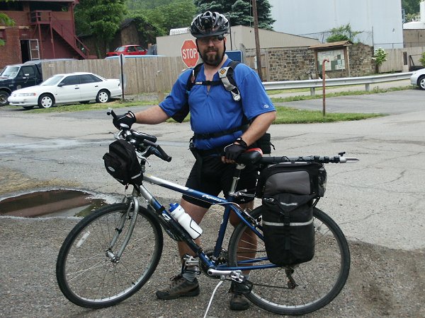
After my ride of 2003 I very quickly decided that I would not wait another 4 years to do the ride to DC again. I also decided that I probably wouldn't ride the MS150 again. I'd been riding the MS150 ride for 13 years or so (I've lost count) and each time it got harder and harder to raise the money. I recall when I started that I worked in a fairly low paying job at Kinko's with a bunch of other people who were in the same financial boat. And yet I had no problem raising the $150 in pledges. Many gave me $20. The average was probably about $12. Everyone gave something, even if it was $2.
Now I'm making more than twice as much in a professional environment and getting my coworkers to pony up anything is like pulling teeth. I've gotten tired of footing half of the pledge obligation myself.
Not only that, but I've become more and more dissatisfied with riding with 1400 other people. On Sunday morning, I get up early so that I'm one of the first through the door for breakfast. I'm on the road immediately after that, two hours before the official start. I make it to the first rest stop before the volunteers get there and it's two hours before other riders start passing me.
And that's the best part of the whole weekend. That two hours when I'm riding alone. And riding the Youghatomic is like that for several days.
At a Bike-Pgh meeting, as I spoke with people there about the kind of riding I do, I said something spontaneously that sort of sums it up: "I'm not sure what I'm looking for, but I'm not going to find it with a group of people."
My wife said that I'm looking for solitude but I don't think that's true. If it were, I wouldn't be so bored and lonely when my family is out of town.
The Youghatomic taught me some other things. First was that I needed to have a tent to keep the mosquitoes at bay if I was going to sleep. The second was the importance of taking a varied diet and eating. In years past I took peanut butter sandwiches and power bars. After a couple of days of only that, I simply didn't eat as much as I should. I lost 10 pounds in the 4 days I rode in 2003.
The loss of that 10 pounds wasn't too bad because I haven't gained it back and so probably shouldn't have had it in the first place but it's not the kind of loss I should make a habit of. This year, I planed to get a better variety of foods. Maybe some MRE's.
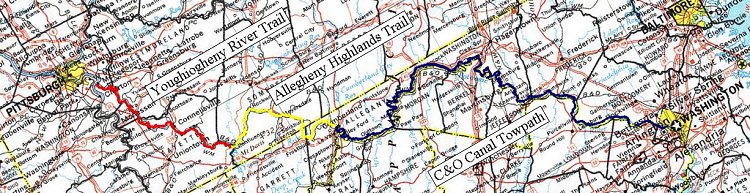
Riding the section between Meyersdale and Big Savage Mt. at night was nice and I would have liked riding the C&O at night if it were a better trail surface. The Youghiogheny and Allegheny Highlands trails are perfect for that so rather than leaving early Thursday morning, I planed on coming home from work on Wednesday, eating dinner and then setting out on the trail. That would give me an additional ten hours or so on the trail so I would be even less pressed for time when I wanted to do things like geocaching or sleeping.
 Wednesday 19 May 2004
I didn't get going as soon as I should have liked. If it were just me, dinner would have been something I could heat up in a microwave or snag at a drive-thru but my wife cooked spaghetti. Lots of good carbs but also lots of time. She also needed to pick up a book order at Borders before dropping me off at the trailhead so, instead of getting on the trail by 6 or 6:30 as I had hoped, it was 7:30 when I finally got going. Well, I thought, leaving as early as I was, an hour wasn't going to hurt. That's why I was leaving as early as I was anyway.
My first order of business was the Too Far To Greenback cache. It's designated as a multi-cache but only sort of. At various places along the trail there are numbered bird houses. Collect the numbers off the bird houses to determine the combination for the lock on the cache. I saw all the birdhouses and noted the numbers but as I ran back into the woods to the cache I realized that I had forgotten them.
It took me a few moments to remember the number again and quickly open the box. I signed the log "Hot! Bugs! TNLN" (took nothing, left nothing) because the sweat was pouring off me and the mosquitoes were zeroing in. When I ride, the moving air keeps me relatively cool and the bug, at least the biting ones, can't keep up. But stop, even for a short period of time and a cloud of heat, humidity and insects surrounds me like a blanket.
I got back on the trail and decided to skip the next cache, Camping Near the Dead, another multi-cache at Dravo Cemetery. It was starting to get dark and I wasn't in the mood for the puzzle and inevitable bugs so I rode on.
Night fell and I ran into my first setback at just before 10:00 pm. A short way beyond the Route 70 overpass I came upon a landslide. A behemoth of mud, rocks and broken trees looming suddenly out of the darkness. I considered trying to go over it but my first step into the saturated mud went over the top of my shoe. I would be hip-deep in the crud trying to go over so I would have to go around.
That meant riding back a mile to Cedar Creek Park and then up out of the valley to Route 51. Then it was back down Route 981 to Smithton. All told it was a hour to traverse the 5 mile detour to end up 3/4 of a mile down the trail.
After that, I started to run into more and more of my second delaying factor. Fog. The wet weather and warm daylight temperatures turn into fog once the night starts cooling off. And the headlamp tends to illuminate the fog instead of the trail, cutting visibility.
"Rock!"
I was past Dawson approaching the River's Edge Family Campground at nearly midnight when, out of the fog there was suddenly a rock. And not just any rock; a ten cubic foot block of doom. The kind of monstrosity they set out at road intersections to keep redneck 4x4's off of the bike trail.
I even said the word out-loud when this rock was suddenly dead ahead and there was nothing I could do. The front wheel hit square on and Newton's Second Law took over. I had hit my brakes in a desperate attempt to avoid the impact but I fear I only slowed myself down enough to ensure that I didn't have enough momentum to clear the rock myself. I went over the handlebars and landed on the rock with my chest. After recovering myself and realizing that I didn't experience the excruciating pain that one would expect with broken ribs, I thought about my bike. Shit! The front wheel must be a pretzel.
Except that it wasn't. By some miracle the front wheel was still perfectly round. However, the front fork was bent straight back so that the wheel was scraping against the frame. I removed the splashguard and there was just enough clearance between the wheel and the frame to make it rideable but to do so felt weird. With the wheel back so far the bike was unstable, like riding with your hands close together. If I turned the wheel too far, my feet would hit the wheel as I pedaled. My GPS had come loose and, in the fall, had lost the left 1/8 inch of the LCD display.
There was much cursing at the night. But cursing wasn't going to help me so I got back on my bike and made my way to Connellsville.
I had a plan.
Thursday 20 May 2004
In Connellsville I was pretty sure I could find the tool I needed and I found it in Riverside Park in the form of a bike rack. I took off the panniers and front wheel and wedged the front fork in the bike rack. Using it as a fulcrum I heaved up on the bike to bend the fork back into place. It was an inelegant solution and I could only get enough leverage to move it a few inches but it was enough to not only make the bike more rideable but it also took away the hands-too-close-together feeling.
![]() Bike repairs in Connellsville.
Bike repairs in Connellsville.
At 1:30 in the morning I was back in business.
Seeing animals while riding at night can be a little disconcerting with their bright glowing eyes caught in you headlamp, but after a while you get used to it and can sort of identify them. When you see those bright eyes up ahead and they suddenly disappear, it's probably either a raccoon or an opossum. By the time you ride up to where you saw the eyes, the animal has retreated into the weeds but raccoons tend to be the more noisy.
The eyes that brazenly keep looking at you as you approach are cats.
But the creepiest things to see are the bright, glowing eyes at person level. When everything else is low to the ground, these eyes at five feet high send the hairs on the back of your neck on end. They will suddenly bob down and back up and an odd dancing motion and only when you get close enough for the headlamp to illuminate the body can you see that it is a deer.
Brrrrr!
It was before four in the morning when I reached mile marker 17, the starting point for the Rocky Riffles cache. The side path takes you down to the river's edge where there is something of a beach. With the headlamp and the fog I could not see much beyond the shoreline. I could hear the water rushing past some rocks but I couldn't see any of them. The water was washing up on the beach in waves like you might expect on a lake and, with only darkness beyond the shore you could believe you actually stood on the edge of a large lake.
I found the cache without difficulty and have actually gotten very comfortable with moving about, climbing rocks and navigating the woods with only my headlamp. When I was younger I was afraid of the dark. Apparently I am completely over that, ever with strange, glowing eyes in the darkness.
Back on the trail, I muddled my way onward, reaching Confluence at 7 am. The Army Corps of Engineers has built a camping area at the Youghiogheny Dam outflow. The charge is supposed to be $3 to camp there but I figured I wasn't actually camping. I simply lay out on a picnic bench for a few hours.
Thursday, 20 May 2004 (continued)
After getting up, I started up an MRE for breakfast. I had gotten some of those chemical heaters so I was going to be living large with a real, hot meal. While that was warming up, I went to the rest room, cleaned the grime off from the night before and changed.
I got on the trail leaving Confluence at noon. . . . just as the rain started.
There were places along the Allegheny Highlands Trail where you could see that previous heavy rains had washed away some of the surface. Nothing like the mudslide near Route 79 or the extensive puddles I was expecting along the C&O but the evidence was there. The trail had handled it pretty well and would probably just need some "touching up" in places.
Around Markleton, I ran into someone who was scouting to do just that. I had seen a ruffed grouse cross the trail and stopped to get a picture of him in the bushes when a pick-up truck pulled up. I told the guy inside, a member of the Somerset County Trail Somethingorother, about the grouse and we got to talking. The question I had specifically was about the trail between the Salisbury Viaduct and Meyersdale.
I had heard a rumor that the trail was complete from Meyersdale and the Keystone Tunnel. I doubted it and had sent an e-mail to the Allegheny Trail Alliance, to be told that the trail was closed from the Salisbury Viaduct onwards. I wondered if the section between the Viaduct and Meyersdale was actually under construction or if, like last year, it was merely undeveloped.
The trail rep confirmed that it was closed and I was going to need to find a way around that mile of trail. I didn't foresee any real problems. I had already looked at the maps and saw that there was a road crossing the trail about a mile back from the Viaduct that I could find my way on.
He also told me that, rather than taking the "official" bypass between Meyersdale and Cumberland by way of Frostburg, I might want to try going to Route 160 and continuing South from there. He said it was much faster. I was a little dubious about someone in a truck telling me that a certain route was faster for me on my bike but I might consider it.
We talked for quite a long time, all the while the ruffed grouse was poking around in the bushes. Clearly he was not going to go to far because he was protecting a nearby nest.
I still had plenty of riding to do if I was going to make it to Cumberland by nightfall so I continued on my way.
It was around 5pm when I reached the Salisbury Viaduct. Rather than turning off to take the on-road bypass to Meyersdale, I had continued on to the Viaduct to search for the High Flyers cache. I wasn't able to find the cache, however. Previous logs had commented on the cleverness of the hide and I suppose I had been on the trail too long to think cleverly. What I did find was a dirt road through a farmer's field less than half a mile back from the Viaduct instead of the road that was a mile back. A small consolation.
In Meyersdale I stopped at the Sheetz to re-load my water supply, snag some candy bars and log a locationless cache, Viquesney's Doughboy. I saw the statue on my ride last year but didn't know that this particular WWI doughboy statue was a locationless cache. And besides, my camera was busted by that time. Earlier this year, I was passing through the area and stopped to log it. But I forgot to take a picture with my GPS in the frame, the proof that I was logging the virtual cache rather than just posting a vacation picture or re-posting something I found on the Internet. This time I had a working camera AND got the picture with the GPS in the frame.
At Sand Patch I decided to continue on to Route 160 and try that alternate route. Route 160 wasn't bad. Instead of the many small hills that eventually climb up first Little Savage and then Big Savage Mountains, Route 160 is fairly level with a mile long climb over Big Savage and then a four mile, 9% grade that has you screaming down into Barrellville. All told it cuts 8 miles off the bypass between Meyersdale and Cumberland. The disadvantage is that you're sharing a no-berm road with cars and pickups doing about 60 miles per hour. On a Thursday evening, however, this wasn't too bad.
The 4 mile run down the mountain was exciting. It was getting dark so I had my headlamp on. At one point I looked down and saw that my speedometer was showing 40 miles per hour! I don't think I've ever been much above 30 and that was scary. At that moment I was absolutely terrified and applied the brakes to bring my speed down to something less death-defying.
I got into Cumberland at about 9pm, an hour or so earlier than I expected had I taken the established Frostburg route. In 1999 when I did this the first time, I had gotten from Boston to Cumberland in about 14 hours. This year it took me 21 hours total.
In Cumberland I washed up in the Wendy's Restaurant restroom and got something to eat. I then went off to search for the Fort Cumberland Virtual Cache, another cache that I couldn't find last year. This time, I carefully followed the signs from on to the next and then ran into the problem of construction. One of the signs was apparently missing. And the cache own had also added a stage that would require you to enter the C&O Canal Visitor Center. As this was getting close to 10pm, that wasn't going to happen. Feh!
I got back on the towpath and rode down to the Evitts Creek campsite. This is a very noisy campsite right next to a major railyard and, if it wasn't so late and I wasn't so tired I would have continued on. Even with the noise I was able to get enough sleep because I was pretty beat. It was nice having a tent and not being eaten alive by mosquitoes but that was a small consolation; I should have been able to get 15 or 20 miles further down the trail by the end of Thursday.
Friday, 21 May 2004
I got up and started. The trail was wet and, as I recall from previous rides, the towpath had plenty of puddles. I would stop at every second or third campsite to wash the mud off my bike as it was gumming up the derailleurs, cables and brakes.
At about 10 in the morning I began to hear this hissing sound. It sounded like some sort of industrial facility venting at high pressure. Except I never passed it. It took a while for me to realize that this sound was coming from cicadas. They sounded different from the cicadas I'm used to hearing further North. The sound just went on and on, hour after hour, mile after mile.
![]() South portal of the Paw Paw Tunnel.
South portal of the Paw Paw Tunnel.
![]() North portal of the Paw Paw Tunnel.
North portal of the Paw Paw Tunnel.
Later in the day I re-investigated my bicycle. What I had thought was simply mud building up on my rear brakes was in fact the back wheel being out of true. It would scrape on one side and then on the other. I don't know how that happened. I mean, I ran into a huge rock and my front wheel survives perfectly true but I ride through some muddy puddles and it messes up my back wheel? Once I got my spoke wrench out and re-trued the wheel things went a whole lot better.
I arrived at Hancock. At the C&O Bicycle shop I talked to the owner, asking what it might cost to have my fork bent back into place. He wasn't able to do it just then as he was technically closed but he said he could do it for $20. I thought that sounded like a really good price and expected that back in Pittsburgh the bike shops would want to charge me more. As it was also after dinnertime he suggested a place about a mile down the trail. I was in the mood for something greasy so I figured I'd ride down there to get something to eat and then ride the towpath for another few hours to try to make up some of the time I had lost.
At the restaurant/truck stop they had a TV playing the Weather Channel. It was a satellite broadcast so it lacked the detailed local forecast but from the composite radar image it looked like we were in for some heavy rain. Just as I was finishing my meal, it did indeed start to rain. So much for a few more hours of riding. By the time I got outside the shower had stopped but the lightning in the distance told me we were in for more so I hi-tailed it back to the Hancock camp site.
Back in front of C&O Bicycles I ran into a trio of guys who had been hoping to stay at there in a sort of Bed & No Breakfast sort of arrangement. He was gone and they were going to need to make some other sort of arrangement. I told them that they were going to have to come up with something quickly because there were storms coming. "Really?" Apparently the rain shower that had come by while I was having dinner had not fallen on them. In any case, they didn't have tents and one of them went off looking for a dollar store to get a tarp or something. They were thinking they might be sleeping under the highway overpass.
For myself, I had a tent and not a lot of time to set it up. As I got the tent out it started to sprinkle. By the time I it was up it was raining harder but the greasy dinner I had started to have an effect. So I ran to the porta-john and by the time I got back, it was a steady rain. Inside the tent was dry but it was extremely hot and humid. I stripped and tried to lay as still as possible so as not to generate any additional heat into the very close environment of the tent.
Last year, I was in Hancock on Friday as well. That meant that the 12 hours earlier that I left on Wednesday had been completely lost.
Saturday, 22 May 2004
It seemed to rain pretty much all night. There were times when it came with thunder and lightning and others when it was just rain but when I decided it was time to get up, the rain had finally stopped. Unfortunately it had seeped into my tent and gotten the bottom of my sleeping bag damp. I was sure I was going to pay for that later. While I was heating up an MRE I packaged up my wet tent. I was going to pay for that, too. Just as I was finishing up, it started to rain again.
It didn't rain hard or for very long, fortunately, but the heavy rains of the night before made the trail ever wetter and muddier than it had been. I learned that riding through the middle of puddles was actually better than trying to ride around. The numbers of people who had ridden around over the weeks, months and years that the puddles had been there made the edges fairly soft. It was easy to get bogged down in the thick mud. But the center of the puddle was somewhat pristine and packed more solidly than the edges.
The cicadas returned, sounding like the Martian war machines from George Pal's movie "The War of the Worlds". This time in addition to the sound I began seeing them on, well, everything. They were on trees, weeks, posts, walls, everywhere. At one point I felt something on my neck. A minor irritation like a shirt tag out of place. Only after half an hour of this did I suddenly realize that my shirt didn't have a tag. I reached back and grabbed a handful of bug. Hitchhiker.
I arrived at Harpers Ferry just at sunset. I decided to actually go across the footbridge to see Harpers Ferry and maybe get something to eat. The first step was hauling my bike up the steps to get to the footpath. Ugh.
Harpers Ferry is a nice, historic town with small shops and cobblestone streets. It's also a National Park that closes down at the end of the day. All the restaurants and shops are closed. I asked a park ranger hanging out in town if there was actually any place that was open and he directed me far up the hill where, after a mile steep climb, I found a pizza shop.
I called Heidi and found out that the storms that had rolled through the night before were severe with high winds and hail. I assured her that I was ok and had endured no such heavy weather, only heavy rain and oppressive heat in my tent.
Heidi wanted to pick me up at 2pm so we would have time to go shopping for good hiking boots at the REI store in College Park, MD and get drive back to Pittsburgh. I knew at that point I probably wasn't going to be able to complete the towpath. At the rate I was going I just wasn't going to be able to cover enough ground by 2pm. It was disappointing but the C&apm;O towpath, because of its poor condition, was beginning to loose its attraction. We agreed that I would call her at 1:00 to let her know where I was and where I would be.
After eating I rode back down the hill and went back across the pedestrian bridge. I wanted to look for the Pterodactyl mountain cache first thing in the morning but the campsite was a mile back up the towpath. I decided to camp at Lock 31. The locks are often fairly well maintained with nice grassy areas.
At about 10 I got to the turn off for the Appalachian Trail. I hadn't passed Lock 31 so I wondered if it was one of those locks that was just a pile of broken stonework, if I had missed it in the dark or if it was further on. I decided to set up my tent right next to a park service sign that, along with other trail information, said that camping was permitted only in designated areas. I didn't think anyone would be along to notice my infraction.
Sunday, 23 May 2004
I awoke as it was just getting light enough to see after a pretty awful night. The sleeping bag was wet and clammy. The tent floor was damp. Even with the rain fly open and lying naked inside, the tent was too hot to be in. When I crawled out of the tent I could see the Lockhouse just a short distance down the trail. I dispensed with the MRE and instead had just a candy bar, changed my clothes and started up the Appalachian Trail towards the cache. It was a hot and buggy climb even that early in the morning but once I got to the overlook the cool breeze and view made the trip worth it. If it were later in the day, the fog would have burned off and I could have seen further but even so, I could see up the Shenendoah River at Harpers Ferry four miles up the Potomac.
![]() Me at Weaverton Heights.
Me at Weaverton Heights.
![]() Panoramic view.
Panoramic view.
![]() Lock 31.
Lock 31.
I spent a lot of time searching for the cache without success. I decided to read some of the logs and noted one that said he had the wrong coordinates. I checked mine and discovered that they were also incorrect. How the hell did that happen? Well, that would explain why I couldn't find this one last year. With the proper coordinates I couldn't find it either. It was very frustrating to have come all this way a second time and still not found what I was looking for.
The cicadas were flying now. I'd be cruising along and "thud", one would smack into my helmet or my glasses.
The towpath condition got worse. Apparently to combat the some of the puddles the park service had put down gravel. The problem was that the gravel had "c" size rocks. (Make a "c" with your fingers. Yea. That big.) It was almost impossible to ride on.
At White's Ferry I called Heidi on the cell and the negotiations began. I had hoped to get as far as the Seneca Creek Aqueduct but the gravel was slowing me down even more. I gave her the choice of meeting me at the Mckee Besher Wildlife Management Center or at Edwards Ferry. With the maps she had at her disposal she chose Edwards Ferry, which was only 5 miles further on. I expected we would arrive at the same time.
I was wrong.
I arrived and waited. And waited. I tried calling but couldn't get a signal on my cell phone. Eventually, a couple that I had been talking to said they were leaving and asked if they could take a message. They would drive out of the valley and call Heidi on the cell phone to give her GPS coordinates to zero in on where I was.
It turns out that Heidi found me shortly after that having driven down one road that took her as far as Seneca and another that took her back towards White's Ferry.
My ride was over at mile 30. I had left 10 hours early and in the end fell 4 hours short of my goal. The equivalent of an entire day of riding had been gobbled up by accidents, injuries, extra gear and sloppy trail conditions.
Epilogue
Before I had left, I had received an e-mail from some guys who were planning a trip similar to mine and were influenced by my postings. (http://www.thirdwave-websites.com/bike/). When I returned, I e-mailed him about the mudslide at Route 70 and the Route 160 route between Meyersdale and Cumberland. The mudslide had been cleared but they decided that they didn't like Route 160. Hey guys, it was only a suggestion. I thought I made better time.
The following Saturday I was driving back towards Washington. This time, my objective was the American Film Institute in Silver Spring, Md to see "Godzilla". Yea, I was driving five hours to see a movie and then drive five hours back. But it was the closest opportunity for me to see the original 1954 version on the big screen in Japanese with English subtitles and without having been cut up to make room for Raymond Burr.
I took the opportunity to drop my bicycle off at C&O Bicycles in Hancock to have the front fork bent back for $20. Everyone I talked to in Pittsburgh wanted to charge me three times as much. The trip was worth it for both reasons, the film and the bike repair.
Will I do it again next year? Hard to say. If I hadn't cracked up my bike and if the trail surface had been dry I could have made the trip in plenty of time. On the other hand, I have no reason to believe that the C&O will get any better. Certainly, the completion of the section between Meyersdale and Cumberland will be a tremendous improvement. Again, it's hard to say.
[Return to Kordite's BikeBlog]
[1999]
[2003]
[2004]
[2005]
[2006]
[2007]
[2009]
| http://www.tasigh.org/gps/gap2004.html -- Revised: 14 June 2004 Copyright © 2004 Kevin A. Geiselman |