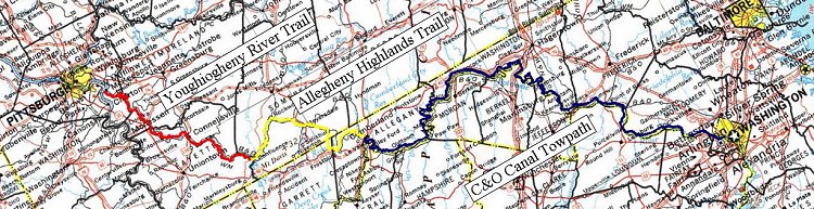
Herein is the tale of my sixth ride on the Youghotomac, the collection of trails that (almost) connect Pittsburgh with Washington, DC.
As with all preparations, they were subject to change. My initial plans were to ride Memorial Day Weekend. That didn't work out and so it got shifted to Labor Day weekend. One of the things I like about the holiday weekends is the extra day off of work. And since I typically plan to be done on the Sunday, I have the Monday to recover, as it were.
For the past four years, I've been leaving after work on a Wednesday to ride the Youghiogheny River Trail through the night to arrive at Confluence at 3 in the morning. And while riding at night is pleasant enough, doing so after a full day of work isn't quite so much. I considered taking half a day off so I could leave 4 hours earlier, to arrive at Confluence at 11pm instead of 3am but I don't have any company loyalty or team spirit anymore so I don't feel I owe them even half a day.
But, even with taking the entire Wednesday off, I still would hit the trail in the evening because of the difficulties in getting to the trailhead before my wife had to be at work. The plan was that I would hit the trail Tuesday evening and ride to Dravo Cemetary, a distance of only a few miles.
Finally, since my wife has announced that she will not be picking me up in Georgetown because of the traffic, I planned on either riding up the Rock Creek Trail, out the Capital Crescent Trail or down the Mount Vernon Trail to be picked up outside of the beltway, thus avoiding much of the holiday traffic. But in commenting on the discussion groups about my plans, someone in Arlington invited me to visit him. We would have lunch and I could be picked up there. Then would mean a 4-5 mile ride out of town on the Custis Trail.
Tuesday 28 August 2007
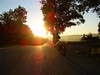
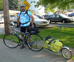 My car was already packed so after work I got home and my wife drove me to the Boston trailhead. I hit the trail at 6:30. It seems that I arrived at Dravo Cemetary almost immediately, it's only 4 miles after all. I consulted the sunset time on my GPS and compared it to the mileage and figured that I could reach the Trekker Campground at Cedar Creek before dark.
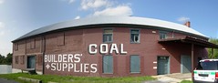
At West Newton I saw the progress they are making on the replica station there that will be the environmental center. It's still not complete or open but outside the door I noticed new Passage maps. I like them a lot. The look much like the C&O maps and I think that continuity will do much for promoting the Great Allegheny Passage and the C&O Canal as a single corridor. The scales are pretty close as well. The new maps are within a few percent points of each others scale. (I wonder why they didn't get them to match exactly.) The old Passage map is a third smaller.
I arrived at Cedar Creek about 8:00 and started setting up camp. The Trekker Campground has a Adirondack-style shelter that still needs some work but I didn't want to fight with insects so I set up my tent on one of the platforms. These platforms are short wooden frames filled with crushed limestone (like the trail surface) so it's smooth, even and you can push a tent spike into it with little difficulty. The crushed limestone allow water to filter through it better than uneven soil might so you won't be camping in mud in wet weather. Nice amenities.
Oh, and camping there is free.
I heated some water in my Jet Boil and made a Cup-o-Noodles ("It's seasoning flavored!"). The County Park Officer came by to check up and said that he didn't think he could ride to DC on a bike. The switch on my flashlight broke, rendering the device useless.
First night on the trail. Ahhhhhh.
Wednesday 29 August 2007
Earlier this year, I found the "On the Canal" trailer on YouTube. Virginia videographer John Urman created the video, initially as a family gift but later available in shops along the canal and online. It's a 30 minute travelogue introduction to riding the C&O Canal. I bought a DVD and said to myself "I could do that."
It's a pretty ambitious idea but as the Great Allegheny Passage nears completion of its connection with Pittsburgh, it could benefit from such a presentation. I've got years of experience riding on the trail. I've written about the trail in these blogs. I've taken hundreds of photographs. I've got presentation experience from teaching at the Carnegie Science Center. I could do this.
What I don't have is videography experience or a camera. But I've got time. Even though Pittsburgh's Mayor has been making a lot of noise about completing the last leg of the trail for the city's 250th anniversary, that's next year and I don't think he's going to be able to pull it off. That having been said, now is the time to get started.
So, as I rode along the trail, I was composing a script in my head. It was somewhat weird in that I've decided compositionally, the film should start in Cumberland and proceed towards Pittsburgh whereas I am starting my ride in Pittsburgh and riding towards Cumberland. I'm scripting the film back to front.
 This trip, as in years past, was also going to involve some Geocaching.Seeking out the Run In The Virgin cache near Dawson, I found a fossil tree. (Fossils are neat.) The Old Overholt Distillery Swinging Bridge Cache took me to a bridge that is not seen from the trail and I would not have known about with the cache to take me there. (Old bridges are neat.)
 Someone on one of the trail mailing lists had made a comment to the effect that he found the Great Allegheny Passage to be "boring". It was just miles and miles of trail and trees. I don't find the trail to be boring at all, especially when you take a moment to look beyond the trail at these hidden gems that are nearby. The key to seeing the Passage (or any trail) as something more than just miles of trail and trees is knowledge. Knowledge of what lies just beyond the trail's edge and knowledge of what those things are. The Overholt Bridge is interesting in and of itself but knowing the history of the distillery and that the whisky originally produced here is still available is even more interesting. Geocaches and, of course, guide books such as "The Great Allegheny Passage Companion" by Bill Metzger are invaluable tools in appreciating the trail.
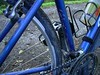
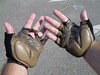 In Connellsville, I stopped at the Bicycles Unlimited shop. The Trico Handshock 1000 gloves that had served me well for several years had become so worn that I couldn't really use them anymore. Trico didn't manufacture them anymore so I sought out a replacement. The Trek Waterloo Classic Crochet Gloves I bought online didn't work well enough, allowing my hands to suffer from circulation and numbness problems. The $30 Trek Moby Gel Gloves I bought failed as well. I replaced my handlebar grips with Ergon GR2 Comfort Grips. The clerk at ProBikes in Squirrel Hill had assured me that the combination of the gel gloves and Ergon grips would solve my problem. They didn't. So, at Bicycles Unlimited I bought yet another pair of gloves. The Trek Traditional Crochet gloves had been the model that I had wanted to replace the Tricos in the first place but had been told they weren't available anymore either.
Riding up out of Connellsville, I found that the Trek Traditionals worked reasonably well. I vowed that once I found a glove that worked I would buy a second or perhaps a third pair so that years down the road when these gloves wore out I could have replacements on hand so I wouldn't have to start from square one should that model have been discontinued. I noticed that I had more problems when riding on harder surfaces (such as pavement) and think I may need to more finely tune my bike's geometry. Lower the seat. Shift the handlebars. Stuff like that.
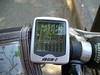 On the ride up out of Connellsville, I officially abandoned hope for my cyclometer. The Filzer dB4LW-C Cyclocomputer I have has a tendancy to turn completely black when it gets hot. And even when it's only warm, the LCD display is completely unreadable. I bought it initially, and paid a little more than I typically might, because it had a cadence sensor. But, it turns out to be a piece of junk. Another piece of equipment I will need to replace.
At Ohiopyle I purchased a map of the Yough rapids. The neat thing about this map is that it's printed on a bandana. The odd thing was that when I first tried to go to the Knot Just a Map website, it was password protected for some inane reason. Bad coding. It took several weeks for them to fix their code. They don't have the Ohiopyle bandana on their website and a number of other links aren't active so I imaging they are just setting things up.
When I film my movie, I'll have to come back for the Ohiopyle Over the Falls Festival, the one day a year that kayakers are permitted to run the falls. On the downstream side of Ohiopyle, the rapids are marked at the trail by cryptically marked wooden posts. ("DS" for example, which stands for the Dimple Rock and Swimmers Rapids.) There is not an easy way down to the river from these emergency access posts. I would like to see better access so that people on the trail could go and see people shooting the rapids. On the upstream side of Ohiopyle, the trail grade is closer to the river and there are wooden steps that take paths down to the river's edge. These accesses aren't marked, even cryptically, to know what rapids you might be looking at. The map bandana is a help but the mile markers on the map (measured from the Youghiogheny Dam Outflow at Confluence) do not match the markers on the trail (measured from the beginning of the Great Allegheny Passage in Cumberland.) Subtract 61.5 miles from the trail markers to roughly match with the river mileage.


 Because I had ridden to Cedar Creek the day before, I arrived at Confluence earlier than I had planned. I should have climbed the hill back near Camp Carmel to search for the second stage of the Carmel Trestle Vista geocache. I should have spent more time looking for the first stage of Mooman's Mojo Multi cache at the Greenwood Bridge. I probably should have tried to work my way down the hill to get a look at Dimple Rock. Without those "time wasters", I had hours of daylight to waste at the Outflow Campground. I wrote some of my movie script ideas down. I walked up to Suder's Soft Freeze and got a large chocolate milkshake. I paid my $8 to camp (up from the $4 of previous years). I got a shower. And even as the sun set, there were still plenty of people in the campsite playing radios into the evening. I had failed to attain a level of exhaustion that would allow me to sleep through their noise. I brought my iPod along so that I could at least not have to listen to their pop radio.
Throat singing from the Tuva region of Mongolia.
Thursday 30 August 2007
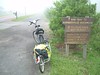 I love leaving Confluence early in the morning. Foggy and quiet are, of course, two plusses, but the sign at the beginning of the Allegheny Highlands Trail sort of sums up the entire point of the experience:
"No cellular service next 30 miles."
Alone. Away. Intentionally out of touch. Well, not so far away as there is certainly civilization along the way and people met on the trail, but the world that I have to live in on a daily basis is far behind me. As the song says, "There ain't no computin' or morning commutin', No 'Parking Lot Full' signs for me, No lawns ta be mowin' or bills to be owin', I'm knowin' the pull of the sea." OK, so it's a pirate song, but the sentiment is the same. Even if only for a few days, I have escaped.
 But being out of touch doesn't mean I'm completely, you know, out of touch. A geocache called It's A Revolution leads me off the trail to a Revolutionary War graveyard. Much like the Overholt Bridge, there is no way you would know that this place was here without being told. It was still pretty dark and foggy and I'm disappointed that I couldn't read what was on the several stones I found. It would be great if some Eagle Scout decided to recover this place as a community service project.
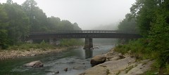
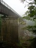 While I was off the trail beside the Pinkerton High Bridge looking for another geocache, I noticed a pair on a tandem on the bridge. They must have stopped on the bridge for a while because I had time to extricate myself from the woods and catch up with them on the shoofly bypass. I rode with them around the horn, talking about the trail and riding. They had stayed in Confluence the night before (in a B&B) and had ridden north and back. On this day they were riding down to Cumberland and were coming on riding back the next day. I stopped at the Pinkerton Low Bridge to take some pictures and they rode on. I expected to meet up with them again.
At the Pinkerton Low Bridge, I went down the trail to the rocks of the Casselman River to take a picture looking back at the bridge. You can still see "Western Maryland Railroad" stenciled on the bridge, a sight you won't see, or even suspect, from the trail. There was supposed to be a benchmark at the east portal of the still-active Pinkerton tunnel so I went the short distance up to the tracks.
I didn't have the USGS description of the survey disk so I wasn't exactly sure where I would find it, so I couldn't. I suspect it was still in place just buried under debris. I took some pictures of the tunnel and went a short distance inside to get a picture from that angle. I wasn't concerned about any oncoming trains because there was plenty of space beside the tracks for access vehicles.
But when I head the sound of a train approaching from behind, I ran. Not because I was worried about being run down but because I wanted to be outside at a decent place to get a picture.


 I caught up with the couple on the recumbent in Rockwood. The fountain at the visitor center still isn't working but it was the first time I've been there when the center was open. I only spoke briefly with 98 year old Maynard Sembower, for whom the visitor center is named. I wished that I had my video camera so that I could do an interview, or just get him to start telling stories of the railroad. When I do get the camera, I will make a point of getting out here as soon as I can to get Mr. Sembower into my trail film. He's getting up in years but is still looking pretty hale so I hope nothing untoward happens before next year.
I went across the bridge to Tin's and bought some chocolate milk for lunch (even though it was not even 11am yet). I had intended that my Cup-o-Noodles be for lunch to keep my energy up and in spite of the Jet-Boil being able to heat up the water in under two minutes, I didn't want to expend the effort to dig it all out of my trailer.
I caught up with the couple on the recumbent again about an hour later between the Salisbury Viaduct and Meyersdale. Recumbents don't climb hills as well as more upright bikes and tandem recumbents are even more sluggish and they were beginning to have second thoughts about the ride back the next day, wondering how their legs would handle the climb up the eastern side of Big Savage. The best I could offer was what I knew of the grade on either side of the tunnel and the expectation that the Meyersdale Station might have some phone numbers of outfitters that might shuttle them and their bike from Cumberland to Meyersdale.
 The Meyersdale Station was closed (only open on weekends) but they found a sign with some phone numbers and were making calls. I rode on to the Bollman Bridge. It wasn't quite done. In may of 2006, the Bollman Bridge had been lifted from its moorings near the Salisbury Viaduct. It sat in a field for quite some time before being dismantled and reassembled near Scratch Hill Road. It was lifted into place in July but here at the end of August it still needed the trail extended to actually meet the ends of the bridge and railings installed. All should be done by the end of the year.
There is a long, straight and exposed stretch of trail between Sand Patch and the Continental Divide culvert. In years past, I found this to be a tough part of the trail because it's so open to the sky (and thus hot) and the increasing grade makes it more of a climb. The 0.8% grade isn't steep, mind you, but I typically am riding this at mid-day and combining the grade with the exposure makes this one of the least pleasant sections of the trail. At just about the time I was thinking about the heat I heard the rumble of thunder behind me. A thundershower at that time would have been welcome but the storm wasn't moving quickly enough. At least the towering clouds kept the sun off my back.
 At the entrance to the Big Savage Tunnel, the cool air racing through the tunnel was meeting the warm, moist air of the approaching thunderstorm to form a fog bank at the entrance. One couldn't see more than 20 feet into the tunnel and the fog was coming out of the entrance a bit like a cheap horror film effect. It didn't last long, however. In the 15 minutes or so that it took me to leave the trail and find a nearby geocache, the fog bank dissipated.
 As always, it was great riding through the coolness of the tunnel after riding in the heat of midday. On the other side I made only a brief stop for a single picture at the scenic view. I had brought a tripod so that I could take a score of pictures to splice together into a single panoramic image of the view. The view deserves that sort of treatment. But with a thunderstorm rolling up over big savage, the view was something less than spectacular. Lots of haze. For my film I will have to schedule a trip back to get the perfect, defining shot.
In the 7 miles between Big Savage Tunnel and Frostburg, there are 20 geocaches. The vast majority of these caches were placed by a single person and, if the one cache of his I found back in December when I came down to ride the newly opened last section of the trail to Cumberland is any indication; they all pretty much suck. I believe very strongly that geocaches are more than just a hidden container you find with a GPS. The adventure you have getting to it or the interesting site you find when you get there is more valuable than the smily face you earn on the website for having found it. The Overhold Bridge and Revolutionary War cemetary found earlier along the trail are prime examples. There is a geocache near Smithton that leads you to the Darr Mine, the site of a 1907 mining disaster that cost the lives of 239 miners. I have placed an earthcache at the Wymp's Gap Fossil Quarry where there is a wooden post labeled F-GR5 near mile 40.7 next to a pile of rocks. You might not know it without the geocache description to tell you but there are fossils to be found there. In July I went on a sailing trip out of Presqueue Isle across to Long Point on Lake Erie to find a geocache there. The cache was nothing special, but the trip getting there bordered on Homeric. This is what geocaching is about.
The score of caches between the tunnel and Frostburg are probably mostly film canisters or tupperware hidden under benches or trailside rock piles. There is absolutely nothing of interest in that. Which is why I blew by them all at 30 miles an hour.
The rain caught up with me on the far side of the Borden Tunnel. I didn't want to turn around and take shelter in the tunnel so I peddled hard for Frostburg. On reaching the trailhead, it was raining fairly steadily and I wanted to take shelter. There was nothing there so I humped it up the switchback to get to Frostburg Station and the Trail Inn. It really started pouring after that and I sat on the porch of the Trail Inn waiting for the storm to pass.
Once the rain ended for the most part, I hit the trail again. The couple on the recumbent tandem caught up with me again while I was searching for a geocache and I passed them once more before reaching Cumberland. I notice that they have built a new parking lot off of North Lee Street in Cumberland. Parking in Cumberland is such a mixed bag and is confusing for non-natives, the Lee Street lot is clearly for trail access.
Again, I am in Cumberland when the C&O Visitor's Center is closed. In my years of riding I have always arrived after hours. Eventually I'll have to make a special trip. I'll also have to ride the Western Maryland Scenic Railroad to include footage for my film. On one of the discussion groups there was talk of racing the train on a bike. I thought of a terrific, though impossible to film, scene where the camera shows me sitting on the train talking and then panning to look out the window to see me racing on my bicycle. Too many special effects for my zero-budget film. I still think it would be a good transition to at least pan out the window to ne me on the bike. I'm sure my wife could do that but it would take paying for a second trip for her riding by herself, and there would only be one chance to get it right. And at $25 a ticket, it's an extravagance I probably can't afford.
That cut scene is going to take a little work to get it the way I want.
I stopped by the Cumberland Trail Connection bike shot due to have its grand opening the next day. I got to meet the ranger hired to patrol the Maryland section of the Passage. It's great to have actual law enforcement on the trail. His presence will help to keep vandals and ATVs off the trail. I wish we could get that sort of coverage in the Pennsylvania sections of the trail, especially in the coal patch areas between Smithdale and Connellsville. The gob piles, leftovers from the mines of the area, attract large numbers of ATVs and they think of the trail as their private access road to these sites.
I didn't stay very long in Cumberland as I need to get to at least the third campsite in on the C&O Canal. The campsite at Evitts Creek is right across from a major railyard, making sleeping nearly impossible. Irons Mountain is right next to a rail trestle. At Spring Gap I decided I still had daylight to ride on so I ended up camping at Pigman's Ferry, 15 miles from Cumberland.
There was a deer standing in the campsite when I arrived and after I pitched my tent and made some soup, I watched a number of deer in the field next to the campsite.
Friday 31 August 2007
The miles rolled by on my first full day on the C&O Canal. In Little Orleans, I left the trail to visit Bill's Place. I'd never been there before and thought perhaps I wouldn't be there this time either because the door was locked. But, just then Bill showed up and opened the door. Even though I was, I didn't want to look like a tourist, so I bought some Gatoraide and a candy bar to mask my gawking at the fabled Bill's Place.
At Lock 56 I jumped on to the Western Maryland Rail Trail, the pavement as always a pleasant change from the "coarse" C&O. The $5 million necessary to extend the trail 4.5 miles to Little Orleans, with access through the 4,350 foot Indigo Tunnel has apparently been raised and construction is due to begin in 2008 with completion in Spring of 2009. There is a long term dream for the trail to extend the 34 miles to North Branch. The trail would cross the Potomac six times and go through three tunnels. It would be a terrific trail. Of course, it could easily take more than a decade to fund and complete.
After years of riding, I finally arrived at Williamsport early enough for the visitor's center to still be open. They had bandanas of the C&O Canal made by the same people that produced the Ohiopyle rapids one, except that the C&O was charging twice as much. It's a sad commentary. Here is a small, volunteer organization in the wilds of Pennsylvania selling a product for $5 to raise money. And here is the Federal Government, managing a national park with taxpayer funds, selling essentially the same product for $10. It certainly costs more to maintain the C&O than it does to upkeep Ohiopyle State Park but I'm not sure I'm comfortable that the 100% markup is justified or managed properly.
 Something I had not known before is that on the other side of the building there are a number of bricks marked with various flood levels over the year. Knee level in 1872 and 1877, waist high in 1972, chest deep in 1987, to the 2nd floor in 1889 and to the roof line in 1936.
It seems to be a statement of pride along the Potomac to have these markings on the side of your home or business. For myself, I'd have probably moved to higher ground.
Before leaving the visitor center, a pair of recumbent cyclists heading North to Pittsburgh came in. It turns out that one of the cyclist was a certified whitewater instructor. We talked a bit and I showed them the Ohiopyle rapids bandana. One of them had a extra tire on his trailer. I couldn't imagine what might cause one to have to replace a tire on the trail as all I've ever replaced a tire for is excessive wear.
When I arrived at the Opequon Junction campsite I still had a few hours of daylight and I considered tackling the Slackwater bypass, the 5 mile on-road detour below McMahon's Mill. I chose rather to hit that first thing the next morning before the heat of the day caused the asphalt to heat up.
The Opequon Junction campsite could use some work. The lower level is muddy and uneven, with plenty of roots to make it unsuitable for pitching a tent. I set my tent up right next to the trail on the upper level. While I had some soup, a nearby fisherman tried to fish from a boat just off shore while speedboats drove up and down the Slackwater. He didn't look very happy.

After dark, I heard a owl nearby. It's hoot sounded like the Beatles' "Coo coo kachoo," or rather "who who huhhoo." I had loaded my wife's "Birds of Pennsylvania" CD onto my iPod so I was able to look up that it was a Barred Owl. In fact, there were two of them. One very near the campsite and another further off.
Saturday 1 September 2007
The Park Service has set out an even earlier point to leave the towpath for the bypass. Normally, one would go to McMahon's Mill and climb the steep hill. Now they have you leaving half a mile earlier. It adds another mile or so on the road but the climb up from the trail isn't as steep (at least if one is heading South). The slackwater bypass at sunnrise isn't too bad. The roads are mostly empty and the temperature hasn't gotten up to life-draining levels.

When I got backdown to the trail, I decided to see how far the trail went North. It had been washed out during Hurricane Agnes in 1972 and I was curious to see how extensive the damage was that the Park Service had been unable to repair it in over 30 years. Above Inlet Lock 4 the trail was very close to the rever and showed signs of erosion. OK, I could see that might take some work to reinforce the shoreline but nothing insurmountable. After about half a mile and a few downed trees and increasing mud, I turned back. Hauling my bike and trailer through that became more unpleasant but again, I didn't see anything that couldn't be addressed.
The numbers I have been able to find for the complete repair of the Big Slackwater area of the park are around $15 million. That's about twice the annual budget allotted to the entire C&O Canal. In the 30 years since Agnes, the seven trail groups of the Alleghgeny Trail Alliance in cooperation with five counties and two states were able to completely build 130 miles of the Great Allegheny Passage, one would think that the Federal government could do something, anything with two and a half miles of towpath. Especially when we are throwing away that much every 100 minutes in Iraq it's really nothing at all
"BANG!"
At mile marker 80, my rear tube exploded like a gunshot. I dismantled things and tried to replace the tube. The new WTB Pathway tire I bought a week before was a bear getting off and on, as if it were too small in diameter. I bent one of the metal tire levers on my Towpeak bike tool. I pumped it up and tested the pressure. 40psi. The minimum pressure on the tire was 50psi and I wanted to get it up around it's maximum pressure of 75psi, so I reattached the pump.
"BANG!"
This time I saw that there was a nearly two inch long tear in the sidewall. I have never heard of a bike sidewall blowing out, especially not in a tire that was only a week on the bike. I had a second tube but, with that big a hole in the tire there was no way it would be rideable. That is, without some jury-rigging.
I wrapped the tube in some electrical tape in an effort to keep it from over-expanding and bursting. I put it all back together and then wrapped the tire and rim in electrical tape in an effort to "patch" the tire. It was completely amateur but it only had to last me the six miles to Shepherdstown, where I assumed (hoped) there would be a bike shop to replace the tire.
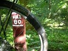
I was able to ride about two miles before I saw that my patch job wasn't quite holding. The tire was bulging and the tear was not completely contained. Rather than riding on it until it failed and then having to roll the rest of the way on the deflated tire (which could damage the rim) I decided to walk the rest of the way. A seven mile ride that would have taken me 45 minutes or so ended up taking me three hours.
Coming across the bridge at Shepherdstown, I saw a pair of kids stunt-biking on the jersey barriers at the end of the bridge. I asked them if they knew of a bike shop in town. They asked if I knew the Chinese restaurant on the main strip. I responded, "If I knew that much about town I wouldn't have to ask about a bike shop. I'm from Pittsburgh." They clearly couldn't tell that by the bike trailer loaded with gear and the three days of road grime.
It was another mile from the trail to the Shepherdstown Pedal & Paddle. I was lucky in that they had only just opened two months earlier in June. Before that, for some unfathomable reason, there had not been a bike shop in Shepherdstown at all. I was also very lucky that they had an appropriately sized tire. I bought it and two more tubes as a buffer. The Specialized Infinity tire went on much easier than the MTB Pathway I had previously, giving me more confidence that it was the right tire for the bike. I also liked that it was rated for the 75-100psi range rather than the 50-75psi range of the Pathway. Higher pressures make for a smoother ride and a lessened possibility of blowouts. I strapped the old tire to my trailer to return to REI for a refund. There is not reason I can think of for a properly pressurized new tire to explode other than it being defective.
I had actually planned to cross the bridge to go to Shepherdstown and do some geocaching but the five hours I lost with the blowout sucked up all that time. I had muffin and some chocolate milk at a bakery across the street and then rode back to the towpath.
I had also wanted to visit Harpers Ferry and perhaps hike up to Maryland Heights but again, the blowout had sucked up the buffer time I had.
I ended my day at the Horsepen Branch campsite at nightfall with just enough time to set up my tent. There were two tents already there, or rather there was one tent (the occupants never emerged) and a tarp. The guy with the tarp appeared to be having a conversation but had no companion. Nor did he have a cell phone. It made me a little wary.
Sunday 2 September 2007
I got up and going before sunrise. It was still a bit dark and I tried to use the bike headlight but it failed to function properly. A bad connection, it would seem, and yet another piece of equipment to fail on my trip.
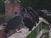 The Seneca Creek Aqueduct was not far and by the time I got there it was plenty light enough to see the flock of vultures that were congregating there. (The collective form of vultures is actually a wake rather than a flock.) All over the aqueduct itself, they were reluctant to move out of my way, uttering a grunt before hopping off. I had the impression that they were a bunch workers waiting at the bus stop, grumpy because it was cold and damp and they hadn't had their coffee yet. No doubt they were waiting for the sun to rise high enough to produce the thermals that would carry them aloft on their morning commute.
The Great Falls Tavern and grounds were apparently undergoing some extensive renovations. Thankfully, at 8:30 in the morning, the crowds I would expect on a holiday weekend Sunday hadn't arrived yet. I went out to the Great Falls overlook with my tripod so that I could get a good panoramic shot.

In all my ride this year on the C&O I had promised myself that I would take any photographs of Blue Herons. Sure, they are very photogenic birds, standing tall and calm enough not to be frightened off when you're trying to take a picture, but pictures of them are as common as dirt on the Internet. You can browse through a flickr photoset without running into swarms of heron pictures. I didn't want to add to that and besides, I've already got enough heron photographs. Except that it didn't work out that way. In one of the twenty or so photographs I took to be spliced together in the panoramic shot, there, on a rock in the middle of the falls, is a heron.
It was an accident. Honest.
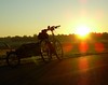
When I was making plans, there were a lot of options for not being picked up in Georgetown. I could ride up the Rock Creek Trail to get picked up in Rockville. I could ride the Capital Crescent to Silver Spring. I could take the Mount Vernon trail to get out towards the Reagan Airport, Alexandria or elsewhere south. Or, I could find my way out the Washington & Old Dominion Trail beyond Falls Church. Anything so that my wife wouldn't have to come into Georgetown and fight the holiday weekend traffic across the Key Bridge. As it turns out, my decisions was made for me when Geoff, a poster on one of the mailing lists, responded to my preliminary plans by inviting me to visit him in Arlington.
So, when I arrived in Georgetown and crossed the trail bridge near the Key Bridge, instead of taking the ramp back down to the towpath I hauled bike and trailer up the steps to get to the Key Bridge itself. Across the Key Bridge, I picked up the Custis Trail that runs along Interstate 66 out of DC. The Custis Trail was pretty tough after 5 days of riding and hauling a trailer full of gear. It's pavement, which is nice, but it's nowhere near level.
It was about 5 miles on the Custis Trail, a mile or so on the W&OD trail and then on the road into Arlington. Before I left Pittsburgh, I had estimated that I would be arriving around noon time. Back in Great Falls, I had again estimated that I would be arriving in Arlington at about noon. I pulled into Geoff's driveway at 11:50 AM.
Geoff allowed me (or rather, twisted my arm until I aquessed) to ride his recumbent up and down the block a few times. I had never ridden a recumbent before and the geometry was wierd. The angle on the pedals from a sitting position was tricky but worse, I think, was trying to steer with my hand hanging down by my sides. There are recumbants with handlebars in front of the rider and I thing I would have been more comfortable with that.
As I was doing that, my wife arrived, asking as I rode by on the recumbent if I was buying a new bike.
"No."
Geoff graciously allowed me to use his shower. Actually, it was probably more an act of self preservation because, even though I try to keep myself clean on the trail, five days of riding come with its own fraguence that would make lunch a less that pleasant experience. And besides, we had a little time to kill as one of his sons was going to joining us for lunch and hadn't arrived yet.
Having de-stinkified, I hauled my bike into his garage and he drove us to a place called The Lost Dog Café. The Lost Dog is the intersection of a great restaurant and animal rescue, the walls covered with photographs of abandoned and unwanted dogs that the owners and their foundation have hescued and found new homes for. The food was good (mmmmm, pizza) and I had some Old Dominion root beer. I recalled having seen a sign two years back on the W&OD trail pointing to the brewery's pub right off the trail. (Their website says mile marker 25.) Before heading back to Pittsburgh, we stopped at a grocery store and bough a few 6-packs of root beer to take back with us.
Epilogue
When I first did the trail from Pittsburgh to DC, a characterized it as an odyssey. Certainly not as epic as Odysseus's travels as told by Homer but an adventure nonetheless. Over the years, as the trail became more and more complete, the inherrent adventure faded somewhat. There were accidents and unexpected circumstances to keep the adventure alive but it became a different kind of a journey. A pilgrimage. Yes, a spiritual journey of sourts but with a specific, physical destination at the end.
Next year, I probably won't be riding to DC. In years past, that comment had been more a sign of fatigue or disappointment but this time I say that with optomism. Having decided to make a documentary film about the Great Allegheny Passage, I expect that many a weekend will be spent on the trail filming. The journey itself will again be the focus, sharpened through the camera's lens.
With all that attention on the Passage, will I even want to take the time off to ride the C&O? Perhaps. I will want to go to DC next year, even if I don't actually ride my bike there. At about mile marker 4 on the Great Allegheny Passage is Bone Cave, a cavern that was opened when the railroad cut through. Inside that cave were found thousands of bones from Pleistocene animals that had fallen in and not been able to escape. At least one specimen recoverd from the cave, a saber-toot cat, is is on display at the Smithsonian Natural History Museum in DC and I envision a cut-away scene filmed there.
The hope is that that Allegheny County and the City of Pittsburgh will actually make good on their intention to complete the trail from McKeesport to Downtown in 2008.
[Return to Kordite's BikeBlog]
[1999]
[2003]
[2004]
[2005]
[2006]
[2007]
[2009]
| http://www.tasigh.org/gps/gap2007.html -- Revised: 29 September 2007 Copyright © 2007 Kevin A. Geiselman |