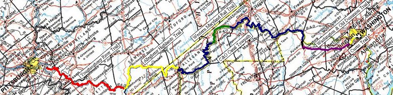
After my ride last year, I had some reservations about doing the Youghatomac ride again. It was the huge numbers of pedestrians and the generally rough trail from about mile 40 into DC that put me off. But then I found out about the Washington & Old Dominion Trail, 45 miles of paved trail from Purcelville, VA to Shirlington, about 5 miles from DC. I could jump off the C&O at Whites Ferry and catch the W&OD at Leesburg. I also heard that the Allegheny Highlands Trail between Meyersdale and Frostburg was supposed to be completed early in 2005. Those two things made all the different and the planning began.
Of course, plans don't mean anything when reality starts to set it. It looked like the AHT between Meyersdale and Frostburg wasn't going to make it's projected opening date. So, I pushed my plans back as far as I thought was reasonable. September. I remembered riding in September in 1999 and it was starting to get a bit cold for sleeping so I didn't want to push it back too far. What with other things on the calendar, it looked like it was going to be Labor Day weekend.
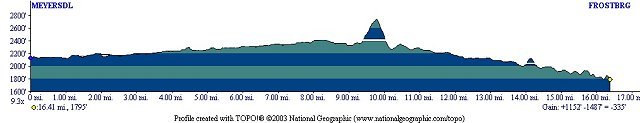
As Spring and then Summer rolled by, the situation continued to change. Some things good, other's not so. The completion date for the AHT got pushed back. And then pushed back again. I was not looking forward to making the 700 foot climb over Big Savage Mountain. On the plus side, the trail from the Big Savage Tunnel down to Frostburg was completed. Then, a 6 mile section on the other side of Frostburg was opened. I looked on some maps and if I took the on-road bypass from Meyersdale and then didn't make the turn at Deal, there was a road that looked like it would take me up to the western portal of the tunnel. There would still be a bunch of road work but I wouldn't have to climb over the mountain.
August 2005
My wife and I did some riding and geocaching on a weekend along the Hoodlebug Trail near Indiana and then on the West Penn Trail above the Connemaugh River Dam. At a geocache there, I jumped down off a log a really twisted my ankle badly. It didn't hurt to ride my bike but for walking it got more and more painful. It healed quickly so that the next weekend I didn't have many problems for the overnight training ride I took on the Greenbrier Trail in West Virginia (75 miles out and then back).
I got new tires. Aired out my sleeping bag and tent. Worked out my packing list and finalized my plans. On the Great Allegheny Passage Yahoogroup, people were asking, as always, for updates on the completeness of the trail. And, as had been happening all this year, someone would say that such-and-such a section was complete and the official from Somerset County would get on and say that it wasn't officially open yet so "keep off." I contacted someone privately who told me that the trail was complete except for two places. One the first was just outside of Meyersdale where there was no bridge. Passing this area would require hauling the bike down and then back up a 30 steep foot embankment. The other was the other side of Deal where SR2011 crossed over the trail. A culvert was being put in place but that could be gotten through or around without too much trouble.
I was encouraged and hopeful but still not completely convinced. I figured I would actually make my decision at Meyersdale.
Hurricane Katrina looked like it was going to make my life personally miserable. At first, it looked like it would rain on me all of my first night and throughout the next day. As the week progressed and the storm moved inland, it broke up and stayed more to the West, making it look like it would just rain on me the first night but dry out the next day. Then it began looking like the rain would stop even earlier.
Wednesday, 31 August 2005
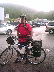 I worked my full day and was very glad to get out of the office and ride my bike back to my car. Home, change, load the car, dinner and then to the trailhead at Little Boston, all the while with a light rain. We pulled into the parking lot at about 7 pm and the rain stopped. I said my good-byes and was on the trail at 7:15.
I noticed that the new Great Allegheny Passage mile markers have been placed. These white plastic markers note the miles from Cumberland. 128 miles. It will be nice counting down the miles instead of having to refer to maps and various calculations. I hope they leave the old concrete railroad marked on the Youghiogheny River Trail North, though. They're a solid piece of the railroad history. I've also gotten used to the numbers as they count the miles from Pittsburgh. Boston is at mile 19. Confluence is at mile 60.
Just the other side of Layton, I stopped to take a short break and eat a Snicker's bar. I looked up and saw two glowing eyes in a tree branch. I moved around some trying to figure out just what it was I was looking at but I couldn't see the animal. It sat completely motionless and I guessed that it was a small barn owl.
As I got going after that, I saw a light further down the trail. It was moving quickly so I figured it was another cyclist. He got closer and closer and we actually nearly ran into one another, him moving over at the last moment.
"I thought you were a building."
My head lamp was so bright that he mistook it for a spotlight on a building not realizing that we were approaching at a combined speed of over 25 mph. That would have been an interesting encounter.
Other than that, I arrived at Confluence at 11:00 without drama. No bike wrecks. No landslides. And no rain. It was a little bit foggy but the temperature cooled off to a pleasant if just a little too humid 65 degrees. There isn't much to see at night but I did notice a number of bat houses along the way. Even had a few bats flit by, apparently snatching bugs drawn to my headlamp. More bats equals fewer bugs.
I arrived at Ohiopyle at just before 2 am and stopped at the station for a cold Gatorade from the machine and a Pop-Tart. I pulled into Confluence at 3:30, just about the time I'd expected to arrive. My pace for the evening had started out at a relatively fast 13 mph but as the hours and miles mounted, my pace slacked off. I also took more frequent breaks as my body got fatigued. I won't say "tired" because riding at night tends to focus your thoughts intently so you don't get tired. At least, not the sleep kind of tired. Of course, that's not until you arrive at your destination.
It wasn't going to get any cooler so I didn't bother setting up my tent. I used my towel to wipe the dew off a picnic bench and just laid my sleeping bag out there. I spent a few minutes looking at the clear and star filled sky before trying to sleep.
Thursday, 1 September 2005
My plan was to be on the trail by 10am so I set my alarm for 9. The sun was bright and warm enough by about 7:30 to drive me out of the sleeping bag. So I got up, packed, ate and cleaned up in the rest rooms. I really took my time and was on the trail at 9:15.
Even accounting for my slower pace, I should have been able to get to Meyersdale before 1 pm. Instead I arrived at 2pm, making my overall pace somewhere around 6 mph. My riding pace was actually closer to 8 mph but I was taking more breaks. Things were starting to get hot. Even so, I was still 4 hours ahead of last year's timetable. I sat at the Meyersdale Station drinking Gatorade from the vending machine there and looked across the street to the barrier blocking the trail. To cross that barrier would be trespassing and if caught I could be arrested and fined. On the other hand, I knew that many other people had done just that without being caught. The alternative was a long hot afternoon riding on asphalt to take a questionable detour and maybe get to Big Savage Tunnel. If that didn't work, it would be a few miles back, more road work, and a strenuous climb up Big Savage Mountain.
I did a bad thing. I jumped the fence.
Just down the trail I came across the gap where the bridge was out. Instead of building a bridge from scratch, the wrought iron Bollman Bridge (1871) will be dismantled and rebuilt to take the trail across Scratch Hill Road. For now, it's a steep climb with my bike down one side and then back up the other.
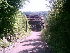 Not far beyond that was the Keystone Viaduct. That is a pretty span as you approach it through a deep cut and see the bridge structure at the end of it. The bridge curves to the left and the through steel truss becomes a simple plate girder span. When the bridge was being refurbished, they knocked out two bridge piers to straighten Glade City Rd. beneath and replaced the three girder structure with a single 240 ft long girder. All told, Keystone Viaduct is 910 feet in length.
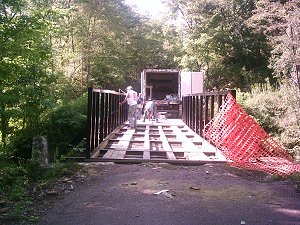 Beyond that I ran into something I didn't expect. A short bridge across a stream with that orange construction barrier mesh across it on both sides. The bridge looked completely refurbished with new decking and a fresh coat of paint and I wondered why it was blocked off. I considered turning back for just a moment and then decided to go on through. It was a simple matter to lift up the mesh and pass underneath.
On the other side, I stopped to get something to drink and just as I was getting going again, a contractor's pickup truck came down an access road and onto the trail. I rode on the unfinished side to give them plenty of clearance and cheerfully waved them by. They passed with a wave of their own. Apparently they weren't upset with my being on the trail. In fact, it was not far ahead that they stopped at a bridge they were working on.
"Good afternoon. Someone had told me that all this work had been completed."
"Nah. Not jus' yet. Go 'head across."
"Are you sure? I don't want to get in anybody's way."
"Go on. No problem. And when you come across the orange mesh just go on under it. If you see my boss, though, don' tell him I said so."
"Absolutely not. So, when is this all supposed to be completed?"
"October. There's another one of these up near the tunnel but the deck is still on that."
"What about the culvert on the other side of Deal?"
"No problem. Go right on through."
"Great. You know, a lot of people are really looking forward to this being done. Thanks a lot."
I didn't ask about the Bollman Bridge but the contractor acted like there were people coming through all the time and they had no problem with it. The bridge they were working on had the old decking still in place and they were just bolting fresh decking over that. I waited for one workman to finish with his power drill before crossing and going on my way. I thought I had laid on the friendliness a little thick but, in all honesty, these guys are making the trail. I appreciate the work and feel they probably don't get a lot of that except in their paychecks. If you run into one of these guys, say thank you for the work they're doing to make the trail ready for you.
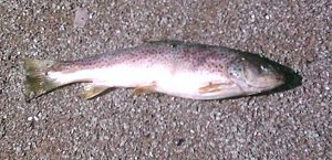 Trout.
Lying in the middle of the trail, there was a trout. A nice looking fish if it weren't for the bloating of decay. So, how did it get up on the trail? And what's weird is that it wasn't the first time that I've come across fish on the trail. No sign of them having been dragged, No bite marks to imply that a raccoon or bear had a hold of it. Just a fish lying on the trail. One would think if a human fisherman had dropped it he would have noticed and picked it up again. A mystery.
When I got to the SR2011 crossing, the culvert was passable. The trail surface hadn't been laid down but it was a packed dirt surface. There was some heavy equipment above, a backhoe moving Jersey barriers. Rather than riding through, I walked to give the workers a chance to notice me and tell me not to go through. They saw me. Then ignored me.
Just before Big Savage Tunnel, I found the road that would have been my way here had I chosen not to take the trail. It was a very rugged and unridable gravel road to access a few houses. I would have had to push my bike up the road. Even so, it had taken me over two hours to travel the 10 miles to the tunnel, time absorbed by having to go under numerous mesh barriers and the increasingly steep grade.
At the western portal of the tunnel my GPS indicated that there was a geocache. I pulled out my PDA to look at what the cache description had to say and it immediately died on me. There should have been plenty of battery power. It had been sealed in a ziplock so moisture shouldn't have been a problem. Well, I was tired and didn't want to climb the hill where the GPS was indicating the cache was so I just chucked the idea and headed through the tunnel.
The Big Savage Tunnel is 3300 feet in length. It has doors at either end that I am told will be closed in the winter to keep the cold winds from causing issues with the lining. Several million dollars were spent rehabbing the tunnel and they don't want ice to break apart all the fine work they've done. It's mostly straight but has a slight bend at the eastern portal. Lights have been installed so I could ride through without my headlamp although there were some dark spots between the pools of light.
There is a nice view just outside the eastern portal and then a fairly steep grade. I doubled my speed going down the hill, through the Borden Tunnel and just before getting to the bottom of the hill at Frostburg got up to 29 mph. With all this in mind, I recommend to people wanting to do the whole Youghotomac that they start at the McKeesport end and travel south. I'd rather climb the long steady incline of the western face of Big Savage rather than haul myself up the stepper eastern face. I did some rough math and the eastern face is three time steeper than the western.
In Frostburg I stopped and talked to some people then proceeded on the recently opened section of the trail between Frostburg and Woodcock Hollow.
Last year when I heard that the Western Maryland Scenic Railroad was not going to get additional funding and was likely going to shut down, I also heard that the bike trail people were at odds with the rail aficionados. It seems that the rail supporters were upset that the trail people wanted to use their space. They were particularly disturbed that a fence would likely be put up to keep trail users off the tracks and such a fence would interfere with their photography of the train.
It sounded a little absurd to me so I actually tracked down a Western Maryland Railroad discussion group and I was astonished to hear the venom that was being slung. These people were filled with hate and blamed the trail people. It was frightening. It's the kind of anger that I hear about when landowners string wire across paths or throw down tacks on the trail because they lost out in a property usage dispute on land that wasn't ever really theirs in the first place.
The topic came up on the trail discussion groups and the leading suggestion was rails with trails. I've seen a few trails where the bike trail runs along active rail without a fence with only an occasional sign warning people that it is illegal and stupid to go onto the tracks. And given that the Western Maryland Scenic Railroad only seems to make one run out and back a day, and only 3 or 4 days a week, there shouldn't be too much trouble. The only issue would be what to do at the Brush Tunnel where there isn't room for both active rail and trail.
At the time, it seemed moot. The railroad was going under so the trail would get the whole enchilada.
That apparently changed as the train is still running, the trail is sharing the corridor at least as far as Woodcock Hollow and there is no fence. I'd like to think that everyone is working together but a recent visit to the list revealed that there is still some bad blood and an on-line petition to "help save WMSR from the hiking path." Apparently there are those who still think we are stealing "their" railroad.
I took Woodcock Hollow Road down to Rt36 and then on into Cumberland, arriving at 6pm. I had hoped to be in earlier but I wasn't doing too badly. I stopped at Hite's Bike Shop for a quick browse to see if there was anything I thought I should have. Being the map geek that I am, I bought a nice set of C&O Canal maps. As if the map, guide book and topo software I already have isn't enough. I went to Wendy's to wash off in the sink and get something substantial to eat. I've found that I don't eat when I'm riding. All I'd had since breakfast was a pop-tart. I'm simply not hungry. If I keep drinking fluids I suppose it's not too bad.
After eating, I still had about 10 miles to get to the Irons Mountain Campsite. I had learned my lesson not to camp at Evitt's Creek as there is a rail yard nearby. It took me about an hour and a half to get there. I set up my tent in the dark, climbed in and tried to sleep.
"Creatures of the night. What music they make." Insects cheeped, chirped, clicked and were generally noisome all night long. On top of that, Iron's Mountain wasn't free of railroad noises. No railyard but there was a trestle nearby. I spent the night lying on my back not sleeping. Then I would roll onto my side to sleep for an hour until the circulation numbness in my hip, arm and shoulder would wake me up. Then on my back until that pain went away and maybe to try lying on the other side. This restlessness punctuated with several passing trains.
Friday, 2 September 2005
It had gotten chilly overnight so I extended the rain cover on the tent. This trapped moisture inside so that when I woke up there was a lot of condensation on the inside. I had no choice but to pack the tent damp. The chemical heater for my MRE didn't seem to work very well so I ended up eating a pressed turkey patty cold for breakfast.
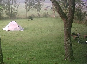 One of the campsites I rode past was next to a farm field. One of the cows had gotten through or around the barbed wire fence and was browsing near a camper's tent. The biker and his wife had been awakened by the sound of chewing nearby and had stuck their heads out see a big black cow face. They prepared breakfast cautiously so as not to spook the animal.
The couple had done a lot of riding. They were apparently visiting their college-attending son (from some nordic country, judging from their accents) and brought their bikes to do a lot of riding. They mentioned Frederick and the Western Maryland Rail Trail.
I just had a thought. There are a number of abandoned lock houses along the C&O. They aren't being used for anything and are just boarded up. Perhaps a slight modification of the attics could turn them into bat roosts. A lock house with a few thousand bats living there could go a long way to controlling the bugs along the canal. Perhaps I'll send an e-mail to the National Park Service with that suggestion.
I arrived in Williamsport at about 5pm. I had set Williamsport as my "stop point" for the day, forgetting that there wasn't an actual campsite there. I would need to ride on to the next campsite to actually set up camp but I had plenty of time to take a look around town, do some geocaching and get something to eat.
The first geocache I looked for was in Byron Park, apparently near a ballfield. Since there was a ballgame in progress, I didn't bother looking for it.
Historic towns don't have crappy places to eat. Because so many of the buildings are older, the fast food places don't get into town to set up shop. All I saw in my quick ride through town was a Sheetz, a tavern and two pizza places. I settled for pizza, cleaned up in rest room and called my wife to check in. I didn't finish the calzone so wrapped it up for the next morning's breakfast.
The next geocache I looked for was at another ballfield on the other side of town. I suspected it was a micro but couldn't find it. I went over to Doubleday's Hill looking for another cache there and couldn't find that one either. Micros. When I loaded up the coordinates to my GPS, I filtered out multi-caches because I didn't feel I had the time to search through all the steps. Maybe when I do this again I'll filter out the micros as well.
Saturday, 3 September 2005
When you ride early in the morning or late at night or really at any time, it's not unusual to come across spider webs strung across the trail. The mornings are the worst, though. Usually they are just single strands strung by spiders getting from one place to another. You watch for dewy glints in the morning light and duck you head to keep them off of your face but sometimes you don't see them. In any case, by the end of the ride your bike, pack and helmet have plenty of webs.
On Saturday morning, the arachnids were particularly ambitious with some spreading full size nets across the middle of the trail. I would catch a glint of web, see something out of the corner of my eye then, whack, I had a face full of web and a spider on the back of my neck. They were usually big spiders, too. Sometimes if the light was good I'd see it in time and was able to skid to a halt but there were a few times that there was no advance warning. Sometimes the threads are so strong you hear an audible "snap" as they break.
For several years of riding this trail, I've been looking at the map and seen Fort Duncan listed just above Harper's Ferry. It was a union fort built in 1863. In 1870, the NGS designated the fort's flagpole as a benchmark (JV4663). It would be neat to log such an old benchmark so from Lock 34, I took Harpers Ferry Rd up the steep hill to Pleasantville Rd. It was a very steep climb on a narrow road. At the end of Pleasantville Rd there was a gate that went down a dirt track to what appeared to be a private residence being renovated. The area is mapped as part of the C&O Canal National Park so I guessed that it is not private property. In any case, across the yard and past the barn I found the remenants of a road through the trees. The road was grown up with thigh-high grass but you could clearly see the broad track.The overgrown nature of the hill and path did not bode well for my search.
The top of the hill where Fort Duncan resided was covered with large tall trees, thorn bushes and stinging nettles. Whacking my way through the weeds with a stick I found the remenants of breventments that I could identify as such only because I knew what it was. To anyone else they would just be mounds of dirt.
Maybe a hundred years ago one could have found the flagpole but today it would take clearing the top of the hill with a chainsaw and weed-wacker and the skills of a professional archeologist to find where the flagpole used to be.
Marble Quarry is the campsite just before White's Ferry. Because there is no place to camp once I cross the Potomac, I had to camp there even though I had plenty of time to ride on if I wanted. This was the first campsite (aside from the mobile homes at Confluence) that had other bikers camping. A father and son had a nice tent. Still small but larger than mine and a style that would allow one to sit up in it. I said that I wanted a tent like that. The father looked at my little tent and said that he wanted something like that for an upcoming trip of his. I offered to trade him but he declined.
With other people in the camp, I wasn't able to leave the rain fly off and lay inside my mesh tent clad only in my underwear because of the heat. But after dark I got tired of being too warm and stripped down to be comfortable. Of course, there's only so much comfort to be had sleeping on the ground. The ground of this campsite was fairly rutted by tire tracks. Apparently when they constructed (or perhaps re-constructed) this camp, they didn't take care to smooth the surface when they were done.
Sunday, 4 September 2005
Since my tent is so small, it is nearly impossible to get dressed while inside. It was still fairly dark when I got up at 6am and my camp mates were still in their tents so I didn't feel bad about getting dressed next to my tent. I'm not that shy. I wasn't sure when the ferry started running so I didn't eat breakfast but instead just packed up my tent and sleeping bag and left.
I arrived at White's Ferry before 7 am. The ferry had been running since 5 but I wanted to buy some batteries for my GPS at the store there but they didn't open until 7. I ate breakfast at a park bench waiting for the store to open. After that, it was a quick ride across the river that cost me a dollar.
People who had ridden from White's Ferry to Leesburg before reported that it was a dangerous stretch. I'd say about half of it had a fairly broad berm and the other half would be more dangerous during higher traffic times. But at 7:30 on a Sunday morning it wasn't bad at all.
 It was half an hour to get to Leesburg and then left onto the Washington and Old Dominion Trail. The first part was pretty nice, tree lined pavement. There was also a trail paralleling the paved trail designated for horses (although I didn't see any). After a while though, a power line took up residence along the bike trail throughway. Power lines require that trees be cleared away from the towers so the trail became much more open and, as the day wore on, exposed to the sun and hot. Signs posted along the trail by the Friends of the W&OD warned of the State Corporation Commission's plans to allow power lines to be put up along sections of the trail that don't already have them.
The W&OD also had a lot of traffic. Bikers, joggers, walkers. It seemed like there was more traffic than on the lower end of the C&O. Part of the reason I chose this route was to avoid the pedestrian traffic on the lower C&O. On the other hand, the traffic was well behaved. The pavement has a dashed yellow line down the center like a road, controlling eastbound and westbound traffic. On the C&O people just walk anywhere.
And the trail also wasn't as flat as I would expect from a rail trail. In a number of places, where there were once railroad bridges, the trail dipped down and then back up.
I stopped at the Herndon Station and visitor center, asking if they had W&OD trail guides. They had a booklet for $6.50. I had thought about buying a milkshake at the Dairy Queen across the street but had decided not to. If I had, I wouldn't have had enough money to buy the guide book. As it was, I had just enough money for the guide book.
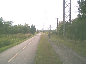
The maps in the guide book indicated that the Custis Trail, my connection to the Key Bridge and Georgetown back to the C&O, started at Lee. Blvd. There was a sign there that directed me off the W&OD onto a street. I followed that for two blocks before the W&OD trail joined up with the road to continue on down the hill together. It was a weird little detour probably left over when only one of the trails existed. After that I saw a number of trail signs guiding me to the Custis Trail. At one point, another trail paralleled the W&OD. It was a little over a mile of that before I actually found Mile 0 of the Custis Trail
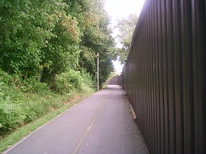 That trail is not scenic. One side has trees and weeds, like many urban bike trails, but the other side has a high metal wall separating the trail from US66.
The Key Bridge crosses back over the Potomac and the C&O Canal. I took a picture of the canal from the bridge that would have been really nice were it not for my finger in the way. My digital camera has a preview feature, I had merely gotten out of the habit of checking.
 Back on the canal trail, I found my wife at The Shops, a small shopping mall that has an entry right onto the canal. She was ready to go but I had one more mission that wouldn't take long. I continued down the canal, past locks 4, 3 2 and 1. Then it was a few blocks towards the river, past the Thompson Boat house to find the C&O mile marker zero.
I came back to The Shops, loaded the car and then went into the restrooms to clean myself up after four days on the trail. Fortunately, they had one of those sinks with a high spout so that I could get my head underneath. I didn't get out the shampoo, not wanting to look like a complete indigent.
Relatively clean, we headed for home.
The totals for my trip were 324 miles in 36.75 hours (at least according to my reasonably accurate odometer). My average speed when I was actually moving was 8.8 mph. Factoring in breaks brings my overall average down to a little over 7 mph.
Plans for next year
I'll stay on the C&O rather than detouring to the Washington & Old Dominion. It's nice riding on asphalt but the exposure to the sun riding the power line cut is tiring. Especially after already spending days on the trail. The scenery isn't all that great, either. Some people find the miles upon miles of trail and woods along the Youghotomac to be boring but I guess I see different things. Miles of asphalt and power lines are boring to me. And the pedestrian traffic is even heavier than the C&O. I'll live through the rough trail and pedestrian traffic of the lower C&O.
The temperatures were nice but I am told that they were unseasonably cool. There were also few bugs than in past years but I am told that is also unusual. Maybe for next year I can schedule early in the year before the bugs while the nighttime temperatures are lows of about 65 degrees. Or maybe I'll wait until later in the year. I'll have to check the climatological information.

I need a new helmet. Actually, I've already ordered a Giro Atmos. Not only is the foam of my current helmet cracked from age, making it less than optimal, I found that when things got too hot I would take it off. A helmet doesn't do you any good strapped to you handlebars so I'm going to get a helmet with even more air vents The Atmos is described as the "most aggressive" helmet on the market with huge vents. It doesn't have a visor but it's an easy matter to pull the one off my old helmet and Velcro it on.
I'd like a new, slightly larger tent. Right now, I have a Eureka Solitaire, a very small and light tent that has just enough room for me. I can't sit up and must exit the tent to change my clothes. I've seen those that have a small, one-person footprint but are higher so that you can sit up in it. The problem is, larger tents means more packing space and more weight. The Eureka Spitfire looks like it will fit the bill weighing only a few ounces more than the Solitarire. This amounts to the added weight of a full size candy bar. If that's all, I might look for something even a little larger than that.
I need a new sleeping bag. My current mummy style bag is too warm for summer use. Something lighter both in thermal weight and packing weight would work.
I really need some sort of sleeping pad. While laying on my back on the ground is not too uncomfortable, I really can't sleep that way. My body wants to sleep on its side and to do that I need something to cushion it. The problems with pads are that they are bulky and my panniers are at their volume limit as it is.
I'd like to take more time. Even though I was pretty much on schedule, I didn't have a lot of time for other things such as geocaching, benchmarking, sightseeing or accidents. There are a number of things going against that. There are currently no camping areas along the Allegheny Highlands Trail between Confluence and Cumberland. Since that section pretty much takes all day, I'd have to camp in Confluence which means pretty much doing the entire Yough Trail in one day (or overnight as I have been doing it). Taking an entire extra day on the C&O wouldn't be bad except that an extra day means an extra change of clothes and another day of food to carry.

All the things I want mean carrying more stuff. More weight and more space. I don't have the space and if I did, say if I bought one of those nifty trailers, wouldn't that additional weight slow me down even more? According to reviews of trailers like the B.O.B. Yak, probably not. Because the weight isn't on the bike, the "rolling weight" is less than the overall weight which theoretically means I could take more stuff but still have it easier to pedal than with the panniers. The B.O.B. trailer is $350, which is more than what I spent on the bike. Maybe I could borrow or rent one.
[Return to Kordite's BikeBlog]
[1999]
[2003]
[2004]
[2005]
[2006]
[2007]
[2009]
| http://www.tasigh.org/gps/gap2005.html -- Revised: 8 September 2005 Copyright © 2005 Kevin A. Geiselman |